ABOUT THE CASE
This research project visualises different aspects of water scarcity in the Fergana Valley, challenging simplified understandings of this issue as related only to technical issues or understandings of water as a passive physical substance. We distinguish diverse perspectives of water scarcity by visualising a conceptual model based on ideas of hydrosocial cycle and political ecology of water.
This research project focuses on water scarcity in the Fergana Valley of Central Asia. Environmental change is often understood as a result of natural forces, and prevailing narratives about water scarcity tend to frame fluctuations in water availability as purely environmental. As a result, the sociopolitical and institutional dimensions of water distribution and management are frequently overlooked, treating scarcity as something separate from human influence.
This visual project invites you to explore the conceptual model of water scarcity in hydrosocial systems. Based on the hydrosocial cycle initially introduced by Linton & Budds (2014) and the ideas of political ecology of water, this study applies a systemic understanding of scarcity in the regional context of Central Asia. Explore the model by navigating through the various concepts.
Water Scarcity in the Fergana Valley
Water is never simply H₂O. It is a technical input for agricultural production, a cultural symbol tied to fertility and life, and a political object through which states articulate sovereignty and control. Scarcity can be seen as a phenomenon that emerges at the intersection of environmental conditions and societal organisation, similar to how the hydrosocial cycle understands water as the outcome of social relations and material flows (Linton & Budds, 2014).
In this scheme, the hydrosocial cycle incorporates the hydrologic cycle as an integral component, reframing water (H₂O) not as a passive physical substance but as an active participant in social relations. For instance, in water governance, technology and power structures shape hydrologic processes such as river flows or dam storage. Thus, the material behaviour of water both stabilises and disrupts social orders, revealing how the movement of H₂O connects the rhythms, livelihoods, and transformations of the environment within the hydrosocial system.
Geography
The Fergana Valley is enclosed by the Tien Shan ranges to the north and east and the Alay–Turkestan ranges to the south. The valley is characterised by a dry continental environment with hot summers and little precipitation, and it relies on storage reservoirs and canal networks. As a fertile basin in Central Asia, the Fergana Valley covers parts of eastern Uzbekistan, northern Tajikistan and southern Kyrgyzstan.
At the eastern end of the valley, the glacier- and snow-fed Naryn and Kara Darya rivers join to form the Syr Darya, one of Central Asia’s longest rivers. As it flows westward, it supports the region’s dense irrigated agriculture. In Tajikistan’s northern districts, which rely primarily on transboundary inflows, the Syr Darya runs for about 195 km; its main tributaries, Isfara, Khodja Bakirgan, Isfana, and Aksu, originate in the Turkestan Range. The primary system of water delivery includes major canals diverted from the Syr Darya river through the Big (Great) Fergana Canal (also the North and South Fergana canals) into a dense grid of main, inter-farm and on-farm canals and collector-drainage networks. This system determines the timing and reliability of water allocation and has allowed for the production of water-intensive "signature crops", such as cotton, as well as locally prevalent rice, vegetables, and apricot orchards.
Case Studies
Water in the Fergana Valley is managed through a complex regional system that reflects both Soviet legacies and post-independence cooperation. Since 1992, the Interstate Commission for Water Coordination (ICWC), together with the Basin Water Organisations (BWO) of Syr Darya and Amu Darya, has coordinated the distribution of water among the Central Asian republics. These institutions set seasonal quotas and regulate reservoir releases from Toktogul in Kyrgyzstan, Kayrakkum (Bakhri Tojik) in Tajikistan, and Kempirabad in Uzbekistan, which determine the water available for irrigation in the Fergana Valley. Negotiations between energy-producing upstream states and downstream farming regions influence when and how much water flows through the canal systems each year.
The valley’s agriculture still bears the imprint of Soviet planning, dominated by rotations of cotton and wheat, now complemented by vegetables, orchards, and small rice fields. Local soil quality, access to markets, and district policies create a patchwork of cropping patterns along the canals.
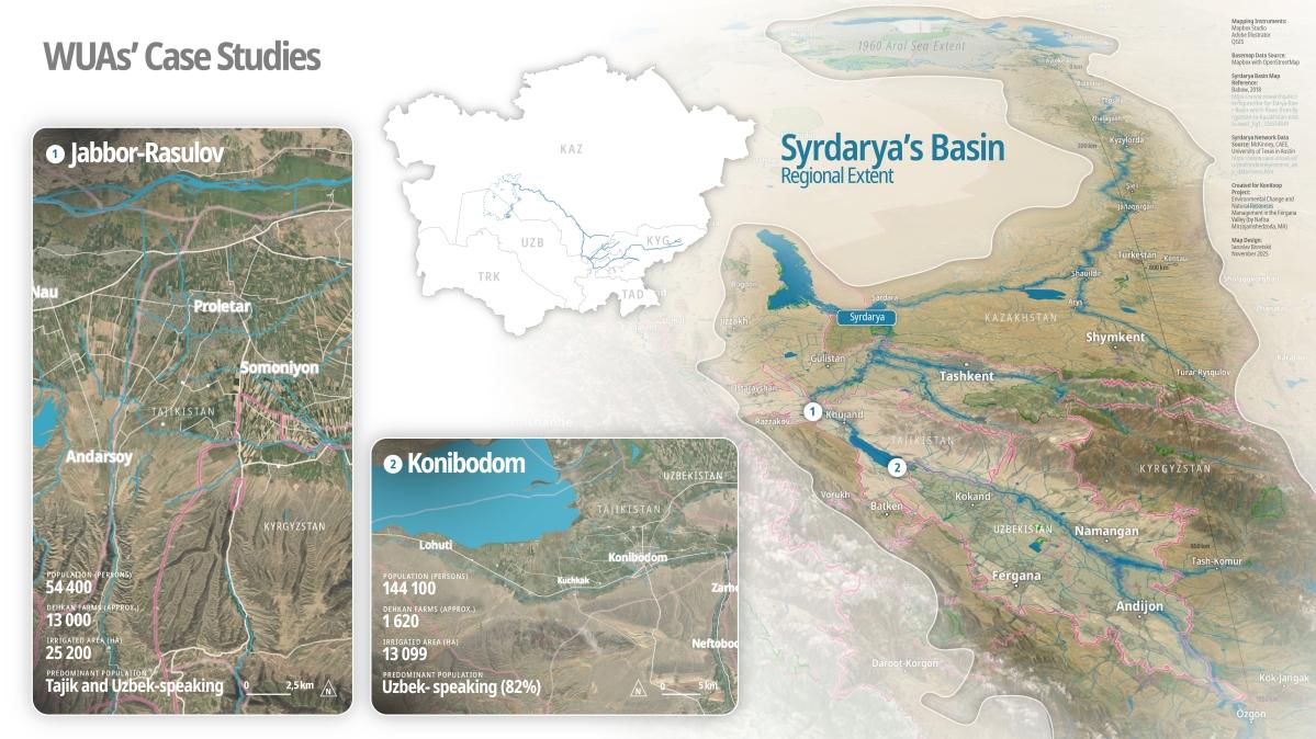
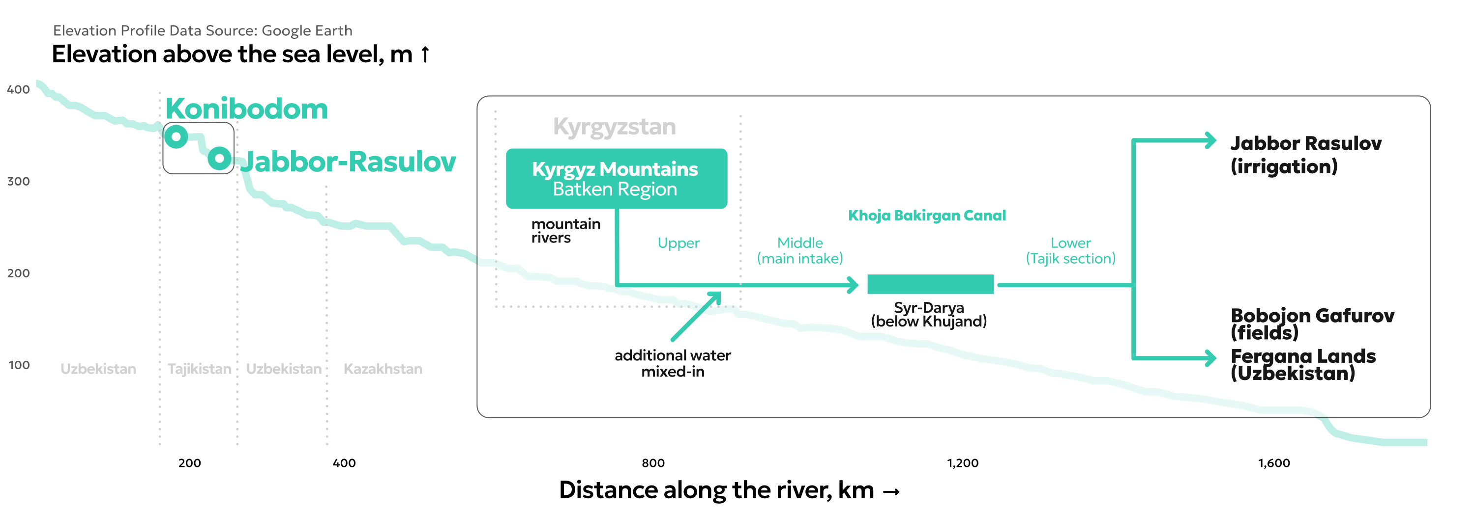
Our case studies focus on Jabbor Rasulov and Konibodom, two districts in northern Tajikistan located at the downstream ends of major transboundary canals along the borders with Kyrgyzstan and Uzbekistan. In Jabbor Rasulov, farms depend on pumping stations along the Syr Darya River and on the Khoja-Bakirgan Canal, which carries water from the Kyrgyz Republic. During March–April and Chilla, the peak summer months, water often arrives late or in smaller amounts to these fields. This makes farmers especially vulnerable to shortages.
In Konibodom, irrigation relies on the Big Fergana Canal (BFC), a 270-kilometre waterway built in 1939 that crosses Kyrgyz, Uzbek, and Tajik territories, as well as diversions from the Syr Darya and Isfara rivers. Around 13,000 farms draw on this more diverse mix of sources, but early-season shortages regularly reduce water deliveries to roughly one-third of the actual demand.
Water scarcity is understood differently across these sites: for engineers, it reflects hydraulic constraints; for farmers, it raises questions of fairness and timing; and for water managers, it becomes a daily negotiation between technical demands, social expectations, and political realities. Together, these perspectives reveal that scarcity in the Fergana Valley is not only a matter of water flow but also of governance, coordination, and trust.
History: Modern Water
Throughout the centuries in human history, irrigation has allowed expansive crop production, enabling the establishment of water supplies to communities living far from natural river flows. The Soviet quest to master water transformed drylands into fields and canals as the instruments of progress. Cotton production was expanded in the Soviet Union's southern republics, particularly Uzbekistan, Turkmenistan, and Tajikistan. In pursuit of these targets, Moscow funded major irrigation projects that redirected the Amu and Syr Darya rivers through canals, reservoirs, and pumping stations, significantly increasing cultivated land. This hydraulic expansion increased cotton production while also setting the ground for significant ecological degradation, the most notable of which was the sinking of the Aral Sea.
These environmental transformations aligned with broader processes of modernisation and industrialisation in the 20th century, whereby large irrigation canals and reservoirs built in the Fergana Valley were designed to integrate agricultural production and move water seamlessly across the internal republican boundaries of the Soviet Union.
By applying the hydrosocial systems framework to irrigation modernisation in Central Asia's Fergana Valley, we can better understand Soviet-era irrigation as a profound reconfiguration of human-water relations. The construction and expansion of large canals, distribution networks, and high-elevation irrigation routes was driven by a modernist logic of control, efficiency, and standardisation, aiming to maximise water extraction. The technocratic rescaling of water systems has transformed not only the physical landscape but also the institutional and cultural relations, such as everyday practices of allocation and negotiation, through which water is governed. After 1991, these legacies persisted in reshaped bureaucracies and basin authorities, leaving a path-dependent governance landscape in which formal institutions often struggled to incorporate local expertise and everyday management practices.
In the late 1990s and early 2000s, water user associations (WUAs) in Central Asia emerged largely through internationally promoted integrated water resource management (IWRM) reforms that aimed to decentralise control and involve farmers directly in irrigation governance. While intended to enhance participation and efficiency, these reforms have not often been aligned with on-the-ground realities (for instance, administrative hierarchies and weak coordination and lack of technical and operational capacity).

Aral Sea and transboundary management
The shrinkage of the Aral Sea, widely associated with Soviet-era river diversions to expand cotton production, continues to shape contemporary water politics in Central Asia. It evokes narratives of over-extraction and environmental injustice between upstream and downstream actors. This legacy reinforces path dependencies in seasonal tensions between agriculture and hydropower that remain deeply embedded in this region. However, the shared recognition of this common past has also given rise to new initiatives for dialogue and basin-wide cooperation. Since 2022, Uzbekistan, Tajikistan, and Kyrgyzstan have renewed their diplomatic efforts aimed at stabilising cross-border water relations. It opened new prospects for negotiations on projects such as the Rogun Dam in Tajikistan and the operation of the Toktogul reservoir in Kyrgyzstan. In addition, regional initiatives have begun to address the long-standing transparency of cross-border water flows. Notably, in 2024, the Blue Peace Central Asia initiative implemented cooperative monitoring systems on numerous key transboundary canals, including parts of the Big Fergana Canal.
Technology/Infrastructure
The Fergana Valley's extensive network of canals, reservoirs, and pumping stations, initially engineered for tightly centralised management, now spans multiple national borders and is increasingly fragmented. This network is not only responsible for irrigation but is also closely tied to hydropower generation, which requires coordinated control of seasonal water releases. As a result, water allocation is entangled with energy needs, reinforcing competing claims and intensifying the flow regulation. In addition, environmental degradation and high evaporation increase water scarcity by reducing the overall efficiency of the system.
Over the past three decades, demands on the valley’s irrigation networks have steadily intensified. Population growth has increased domestic and household water needs, competing directly with agricultural use during summer peaks. Agricultural diversification and economic shifts have intensified cropping cycles (for instance, through double harvesting, greenhouse production, and water-sensitive orchards), which require more precise and frequent irrigation rather than seasonal delivery. These are compressing irrigation windows and making farmers highly vulnerable to water shortages.

Social Structure & Power
Socio-politics of water scarcity
Since the independence of Central Asian countries in 1991, the disputes over water allocation between Kyrgyzstan, Tajikistan, and Uzbekistan have often carried meanings that extend far beyond water volumes and flow rates. At the transboundary level, asymmetries among states are equally evident: Kyrgyzstan and Tajikistan’s upstream control of reservoirs contrasts with Uzbekistan’s downstream demand for irrigation water, creating conditions in which scarcity becomes entangled with hydro-hegemony. In this sense, scarcity is less about absolute shortages and more about how power and negotiation determine whose needs are prioritised.
Power of spatial configurations
The configuration of irrigation networks in the Fergana Valley places certain communities in downstream positions, shaping both their access to water and their exposure to scarcity. Being downstream is thus not merely a hydrological condition but also a socio-political one, as it reinforces hierarchical relations within irrigation governance and results in an uneven distribution of scarcity along the canal system.
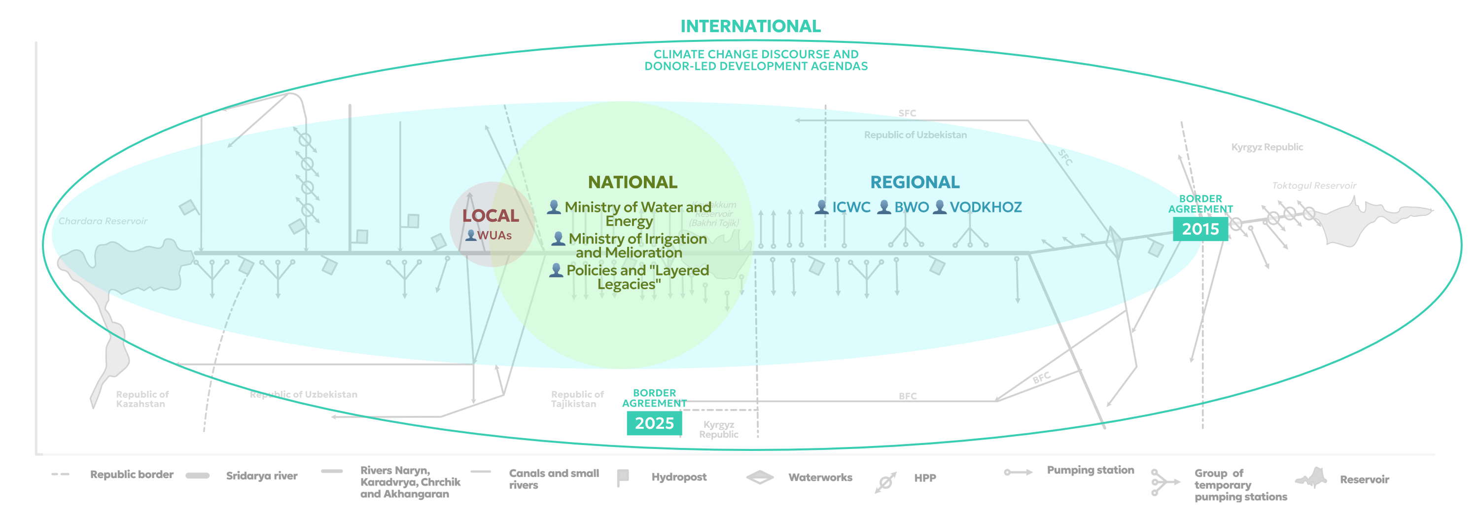
The ontology and epistemology of water
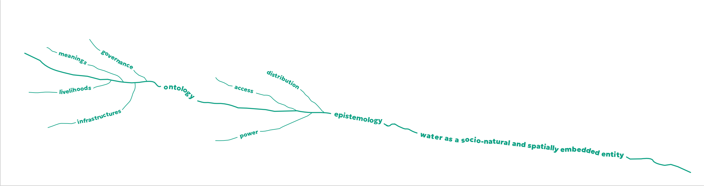
The epistemology of water asks how we know water, and these ways of knowing also shape the understandings of “scarcity”. When scarcity is defined primarily by volumetric measures (e.g., cubic meters per capita), it privileges technocratic logics and can obscure questions of access, power, and distribution. The ontology of water asks what water is: merely H₂O moving through a hydrologic cycle, or a relational entity embedded in infrastructures, water governance, livelihoods, and meanings it produces. Understanding water as a standardised mobile resource presents scarcity as a natural shortfall that new storage, transfers, or efficiency technologies can address.
This is the core of resourcification: water is transformed into a standardised commodity, measurable, priced, and governed by uniform rules, thus framing scarcity as a technical and economic issue. However, when water is understood as a socio-natural and spatially embedded entity, scarcity takes on political and ethical dimensions – it becomes tied to historical narratives of inclusion and exclusion, shaping water rights, institutional arrangements, and the unequal experiences of its users.
These contrasting epistemologies and ontologies do not merely describe scarcity—they actively produce different understandings, making certain interventions possible while sidelining others. Acknowledging these epistemic-ontological differences expands the range of responses beyond technocratic fixes in water governance, opening space for justice-oriented, context-specific approaches and the plural knowledges of diverse water users through participatory perspectives.

Adaptive practices: Groundwater
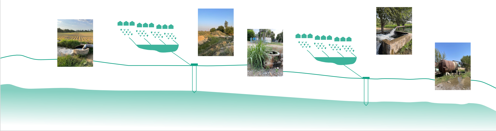
In the Fergana Valley's downstream systems, groundwater extraction has emerged as a key adaptive approach in response to increasingly unreliable surface irrigation during the vegetative season. Farmers and households rely on wells to obtain water for crop survival from the early watering periods (typically beginning in late March to mid-April) through the summer months of peak agricultural demand.
Local groundwater techniques are diverse and socially integrated. Some actors invest in deep wells (up to 120 metres) or hire private drilling operators to develop personal or group reserves. Others rely on communal pumps or informal sharing agreements reached at the mahalla (neighbourhood) level between neighbouring farms. These partnerships, which are based on familial relationships, land proximity, or long-standing social ties, may include reciprocal labour, seasonal payments, or in-kind contributions.


The shift to groundwater reveals a contradiction between formal regulatory institutions and the lived hydrosocial practices that support rural livelihoods. Groundwater has symbolic significance in downstream zones of the Valley, where canal flows are lowest and distribution tends to be unbalanced against tail-end users: it represents self-reliance and a form of hydraulic autonomy. However, intensive pumping leads to long-term aquifer depletion and salinisation, whereas a lack of coordinated monitoring obscures accountability across administrative boundaries.
Understanding groundwater as an adaptive practice rather than a technical reserve uncovers the intricate negotiations and invisible sovereignties that shape water access in the Fergana Valley. It underscores that scarcity is not only a question of physical volume but also a product of institutional fragmentation and the shifting temporalities of survival.


ABOUT THE AUTHOR
Nafisa Mirzojamshedzoda is a PhD-student at Eberswalde University for Sustainable Development (HNEE), Faculty of Forest and Environment, and the University of Fribourg. She completed her undergraduate studies in Political Science and Anthropology at the University of Heidelberg and received her Master’s degree in International Development Studies from the University of Marburg and Sogang University in Seoul.
Roles
Author: Nafisa Mirzojashedzoda
Visualisation concepts: Mela Žuljević and Iaroslav Boretskii
Visualisations: Mela Žuljević and Iaroslav Boretskii
Cartography: Iaroslav Boretskii
Photography: Nafisa Mirzojamshedzoda
DataLab: Ivaylo Dinev
Advisor: Jana Moser
Schemes and Diagrams
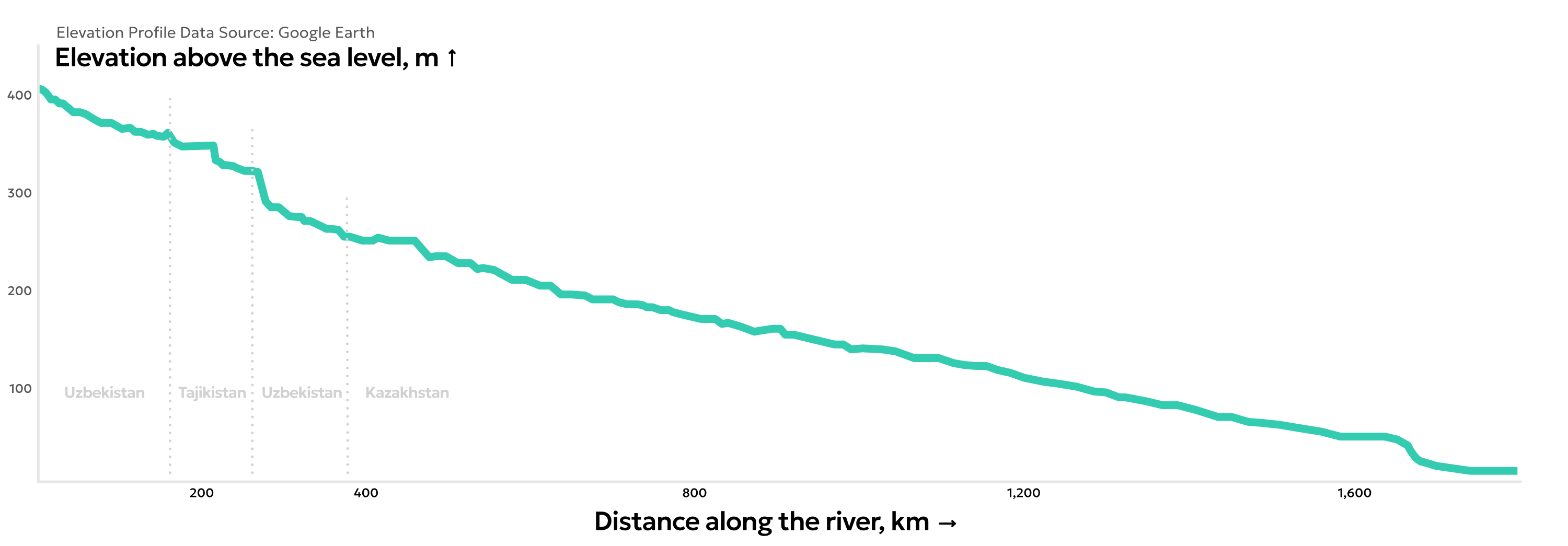
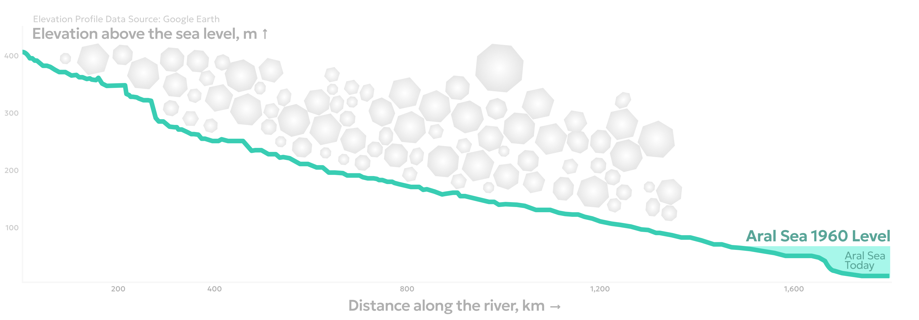
Iaroslav: A river profile as the visualization method was somewhat a compromise on finding a way to uniquely focus the entire visual narrative on the Syr Darya itself. Its basin occupies a very complex spatial setting of Central Asia. Originating in the mountains and crossing multiple borders, the river might be perceived primarily as a result of political divisions. What method would keep the focus strictly on the river? Thanks to my bachelor times, I recalled the practice of constructing geographic profiles which served as a very specific analytical mapping technique. River profiles, in particular, give an immediate insight into the vertical\horizontal dynamic of the mainstream. Such an underrated method seemed entirely appropriate. We can clearly see the scale of the river, how steadily and evenly it extends across hundreds of kilometers, and at the same time how different states control it all the way to its mouth in the Aral Sea. Ultimately, a river is a product of climate interacting with terrain. In this sense, the profile gives proper attention to the river itself and may represent one of the most ultimate — and politically neutral — forms of its visualization.
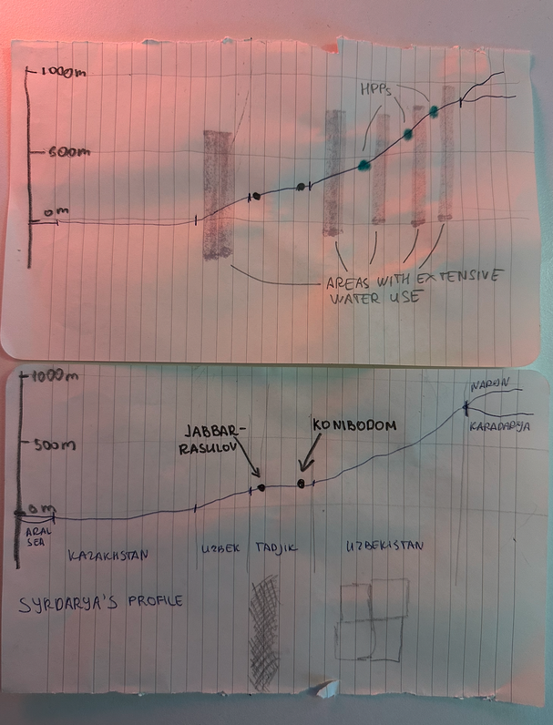
Mela: At first, I thought the geographic profile would be an interesting approach to do the exact opposite of what Iaroslav suggested above, namely, to articulate the political hierarchies along the river stream. Producing politically neutral representations is not what the VisLab is interested in. Rather, it is the opposite: finding ways to visualise the complex politics and the multiple perspectives around water scarcity in the Fergana Valley. Still, we agreed on the geographic river profile to be a good starting point for engaging with this complexity, precisely by starting from a simplified visualisation of upstream-downstream relations.
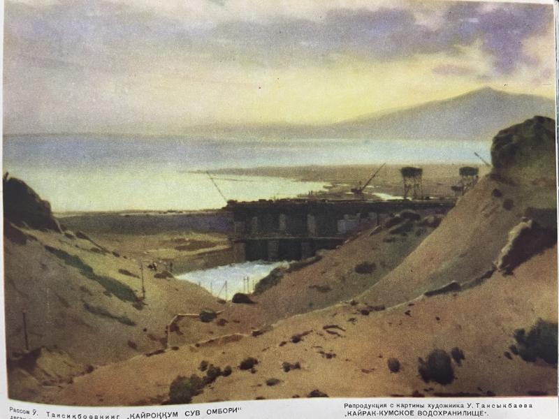
Nafisa: The illustration was intended to question the simplified formulation of upstream-downstream water conflict, as the asymmetry within the river basins is multidirectional rather than linear. For example, Uzbekistan has both upstream and downstream positions along the Syr Darya, influencing certain stretches of the river while remaining dependent in others. This perspective is further illustrated by this diagram (the reproduced version of the old scheme I found in Dushanbe) that emphasises the system's structural complexity. Here, the system itself is seen as part of the problem. Following the dissolution of the Soviet Union, political authority was rescaled along newly established national borders, but the integrated hydraulic infrastructure remained mostly unchanged. The misalignment between political sovereignty and hydrological interdependence is argued to be the structural condition that continues to shape transboundary water governance in Central Asia.
Mela: For this reason, we started from the elevation model, but explored other ways to show diverse perspectives. The horizontal layout was repeated in these perspectives, but some presented more of a technical drawings, other conceptual and network visualisations. In this way, we developed a visual format with different instances which corresponded to the different perspectives. Most importantly, Nafisa wanted to represent these various perspectives in a model. So we developed this conceptual scheme which could be used to navigate the different perspectives.
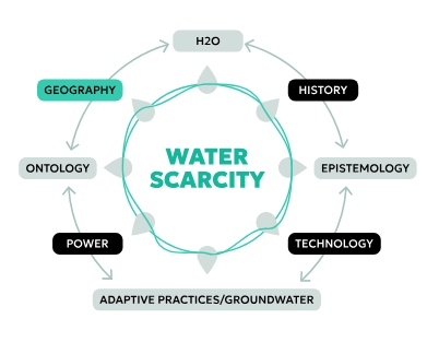
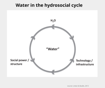
Nafisa: The model diagram is based on the hydrosocial cycle as conceptualised by Linton and Budds (2013). See the original sketch from their publication below for reference. Following its logic, water is produced through socio-political and institutional configurations, while simultaneously reconfiguring these systems through its uneven distribution and availability. Surface water scarcity, therefore, cannot be understood only as a physical phenomenon but as a process emerging from and continuously transforming the social organisation of water. In this process, surface water scarcity both reflects existing governance structures and actively transforms social relations (between water users/institutions), livelihood strategies, and everyday negotiations over (ground)water, which continuously reproduce the system itself.
Mela: We discussed how the elevation model was simplified in its attempt to show the unevenness of upstream and downstream communities in how they were affected by the water management system and water scarcity. The first scheme for the adaptive practices was also too simplifying in visualizing the groundwater reservoirs upstream can supply a larger number of farmers in relation to those downstream.
Nafisa: Yes, this illustration seemed somewhat confusing and could lead to misunderstandings, as it is not aligned with the arguments developed in the case study sections of the text.
Mela: As an alternative, for now, we decided to integrate Nafisa’s photography as a visual representation of situated practices around groundwater. But we plan to rethink the approach and develop another solution, as the atlas is a living document and the process will be recorded here.
Maps
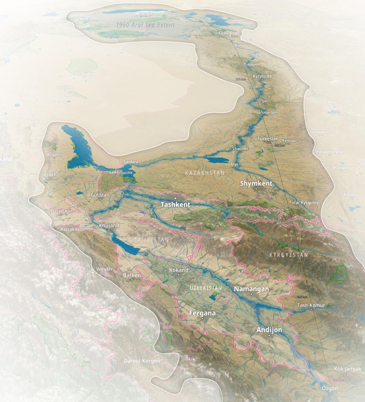
Iaroslav: I worked with this map back in November 2024 as Nafisa was preparing upcoming participatory mapping as well as demonstrating project’s peculiarities during her academic presentations. As with the river profile visualization, it was important to find an unconventional way to frame the basin’s extent — in this case through a three-dimensional perspective. I believe this view is especially powerful because it introduces a tangible sense of spatial dynamics. In the mountainous headwaters we observe intense territorial contestation, almost as if witnessing the extensive efforts to utilize the river’s resources at its origins. At the same time, looking into the distance above, we see the vast, nearly proportional extent of the dried Aral Sea, which became a notoriously disastrous ecological issue due to the extensive use of water resources.
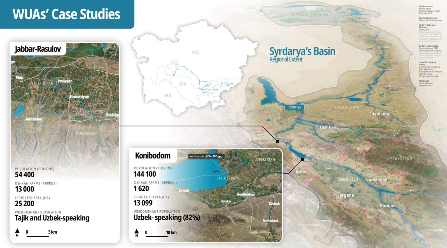
On a more personal note, regardless of the project's relation to water management, the Syr Darya holds particular significance for me because I was born and spent the first years of my life in the city of Baikonur located on this river. In that sense, the mapping process was also a bit emotional and driven by an inner desire to present the river from a different perspective.
Technically, I used the Mapbox 3D engine, added basic boundary and labels layers, and then exported the composition into vector software — specifically Adobe Illustrator — where I added additional annotations in separate layers. I consider this one of my favorite works within the KonKoop project because it was my first attempt at something resembling a three-dimensional mountain panorama map (which I am a big fan of), and Mapbox tools made it possible to create truly compelling visualizations.
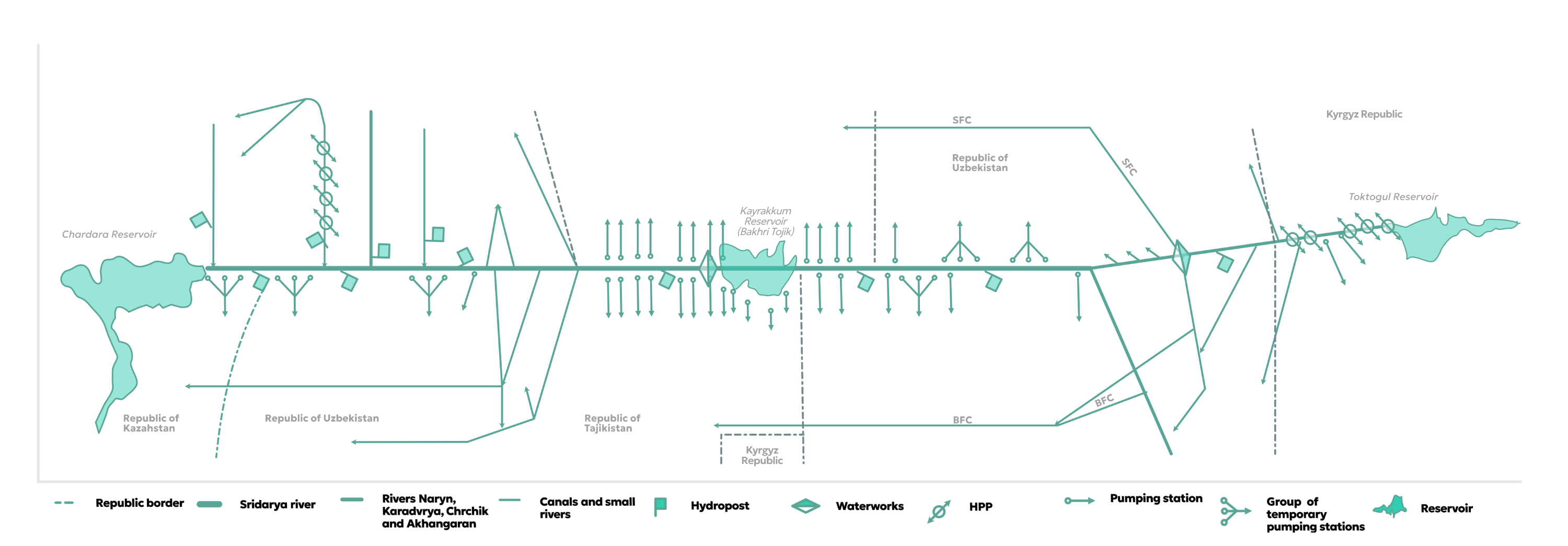
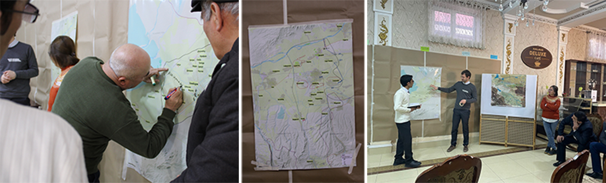
Nafisa: The graphic demonstrates how both case study areas are connected to and interconnected through the Syr Darya River. By marking major reservoirs and dams, such as Toktogul, Kayrakkum (Bahri Tojik), and Shardara, as well as situating the discussion within the wider Aral Sea basin, the illustration highlights the transboundary character of the system. In doing so, it makes visible the infrastructural linkages that tie local livelihoods to basin-wide water governance dynamics.This illustration was later adapted and used during our participatory workshops with farmers, where it served as a visual tool to discuss and define the geographical scope of their livelihoods. It helped situate local experiences within the broader river basin and facilitated reflection on how everyday water use is embedded in larger hydrological processes. Here are also some photos, where farmers were working with the maps we developed:
3 Photos
VisLab: Nafisa, could you tell us more about your photos and using photography in fieldwork? How do they contribute to your fieldwork and add different types of insights?
Nafisa: Most of the photographs were taken as part of the participatory observation process. During this period, I accompanied farmers in the early morning hours. These moments provided insight into the everyday practices through which water distribution is organised (and sometimes) contested at the local level. At the same time, the research moves beyond a purely human-centred understanding of water use. Rather than focusing exclusively on water users as decision-makers, it also considers the role of non-human actors and material agencies, such as infrastructure, river morphology, soil conditions, and technical devices, in shaping water flows and access.
The images also highlight environmental degradation and infrastructural inefficiencies within the transboundary system, illustrated here by the example of a pumping station. Such infrastructure not only enables distribution but also produces losses, and challenges of management that affect availability of water downstream.The reliance on energy-intensive pumping highlights the structural inefficiencies of the system and shows how infrastructural design translates directly into economic pressures for farmers, who must take the resulting operational costs.
Finally, the photographs capture the apparent contrast between scarcity and abundance. Importantly, scarcity is not treated as an absolute condition, but as a relational and temporally shaped phenomenon. It depends on seasonal timing, agricultural cycles, crop choices, soil characteristics, elevation, and the coordination of water releases (all part of the system). What appears as scarcity at one moment may coexist with relative abundance at another, underlining hereby the dynamic and context-dependent nature of water availability.