ABOUT THE CASE
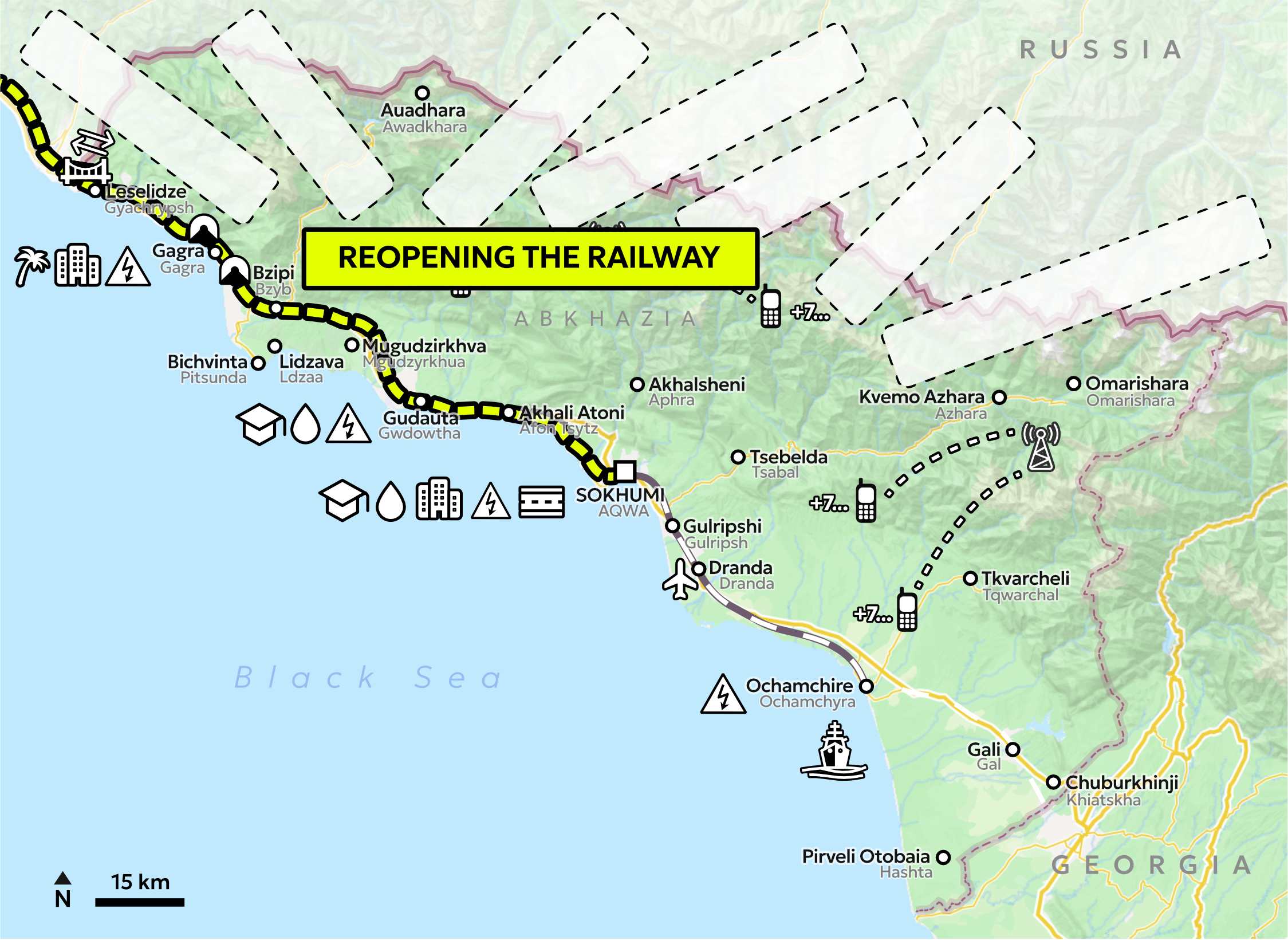
The case is based on an interactive map format which visualises the construction and development of corridors, ports and routes with the aim to capture how infrastructure linkages between Abkhazia and Russia unfold through time. In the map, we explore the use of icons and symbols to represent these connections, but also the less visible (and harder to visualise) aspects of economic agency: the underlying currents of the patron-client relations such as long-term supply contracts, special legal regimes, military agreements, language and education policies, etc.
Introduction
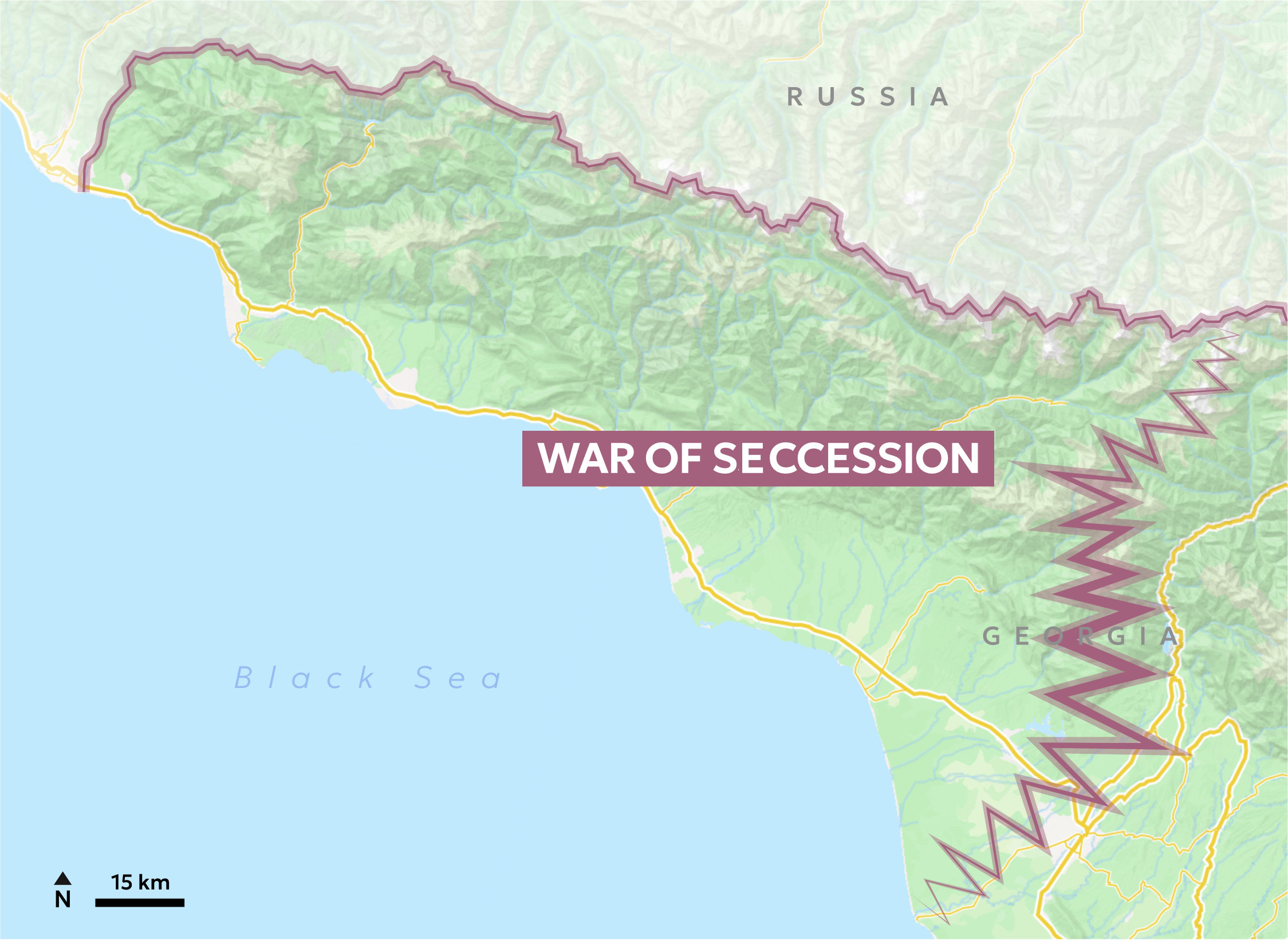
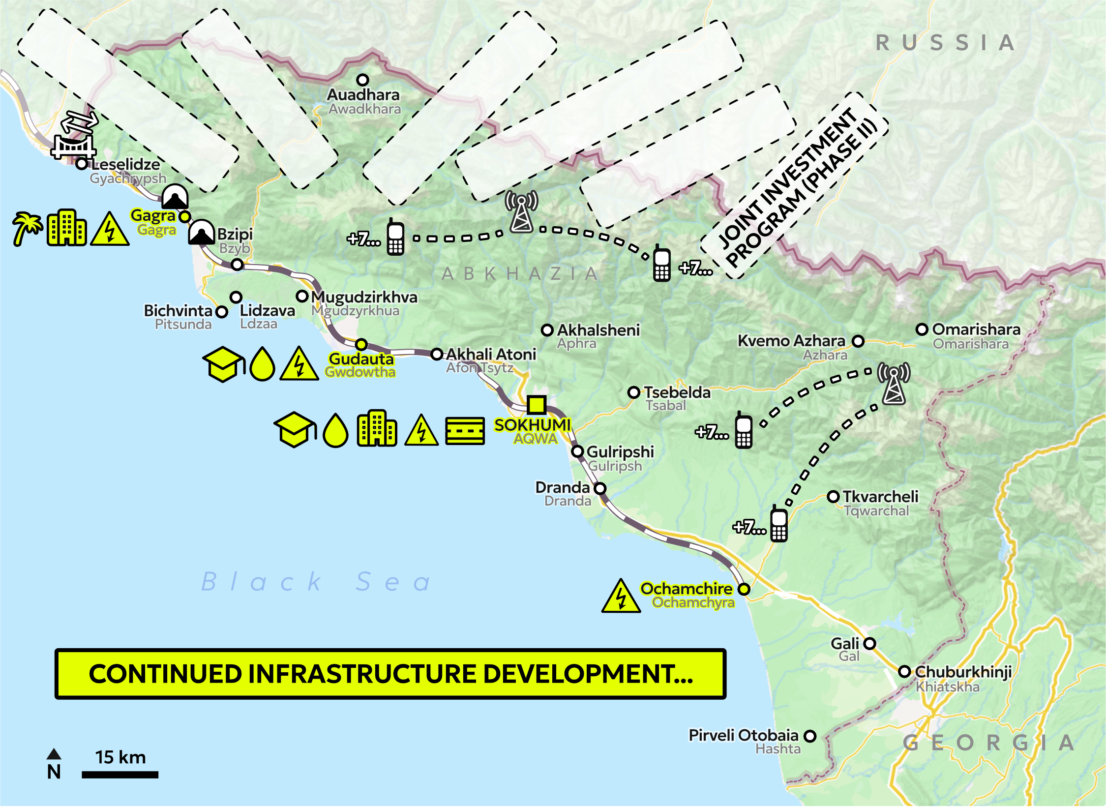
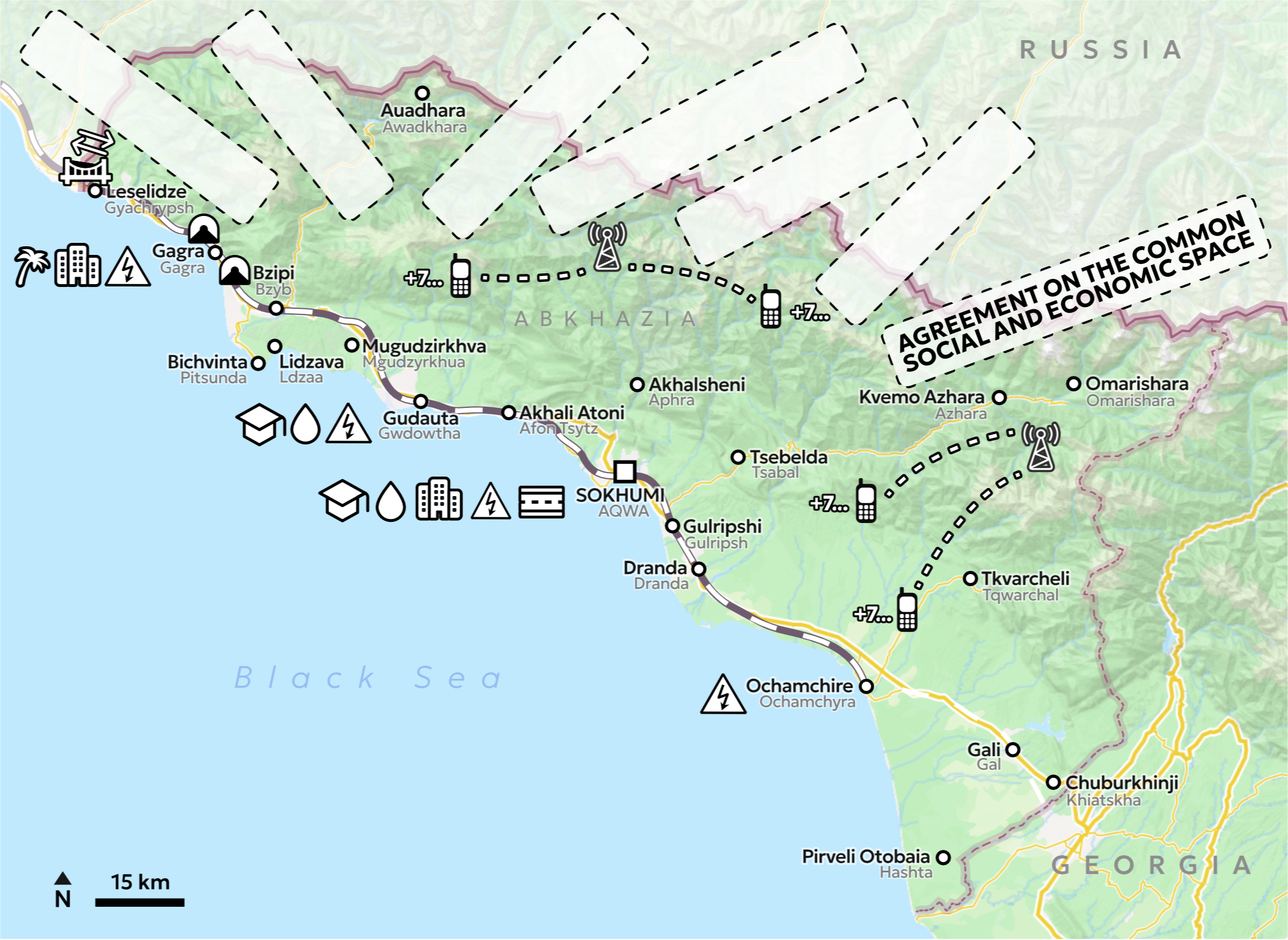
This interactive map captures the developments in infrastructure linkages between Abkhazia and Russia since Abkhazia’s secession of Georgia 1992-1993. The time and spatial dimensions reveal changes, patterns and trends within the relations of Abkhazia to its patron (Russia). Focusing on infrastructure as an example of economic and political linkages, the interactive map offers to visualise connections in forms of corridors, ports and routes. This should enable to transform a “container view” of space to a “relational view”.
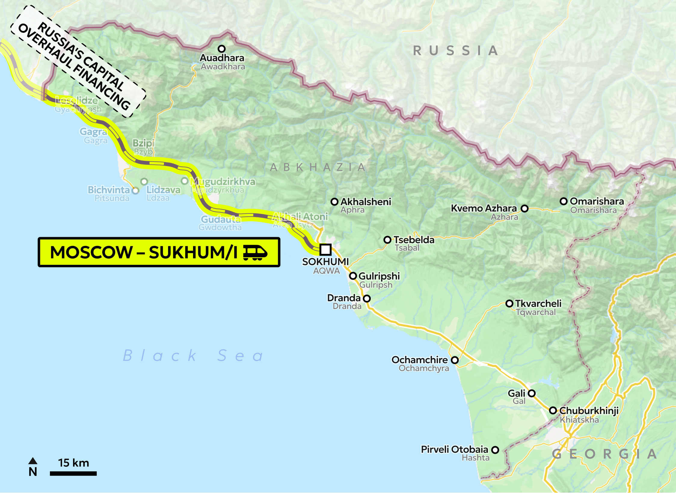
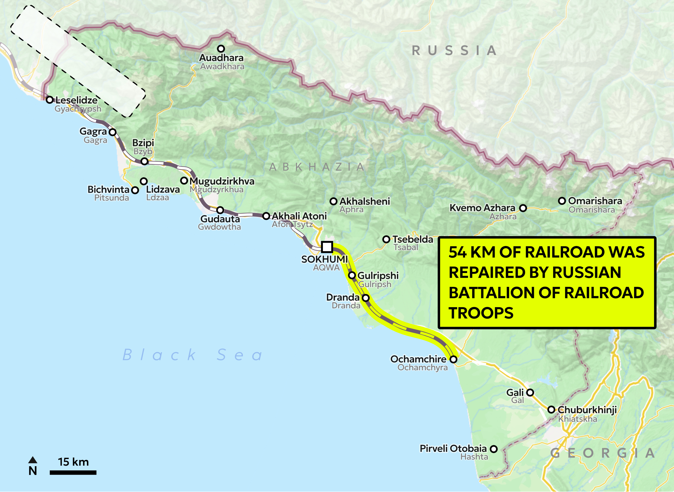
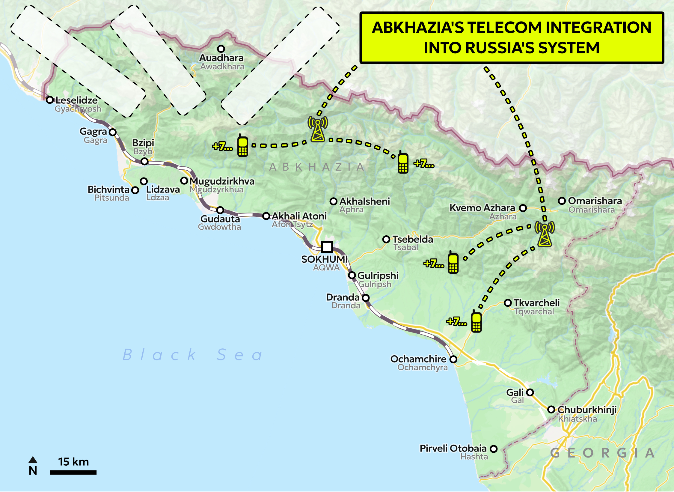
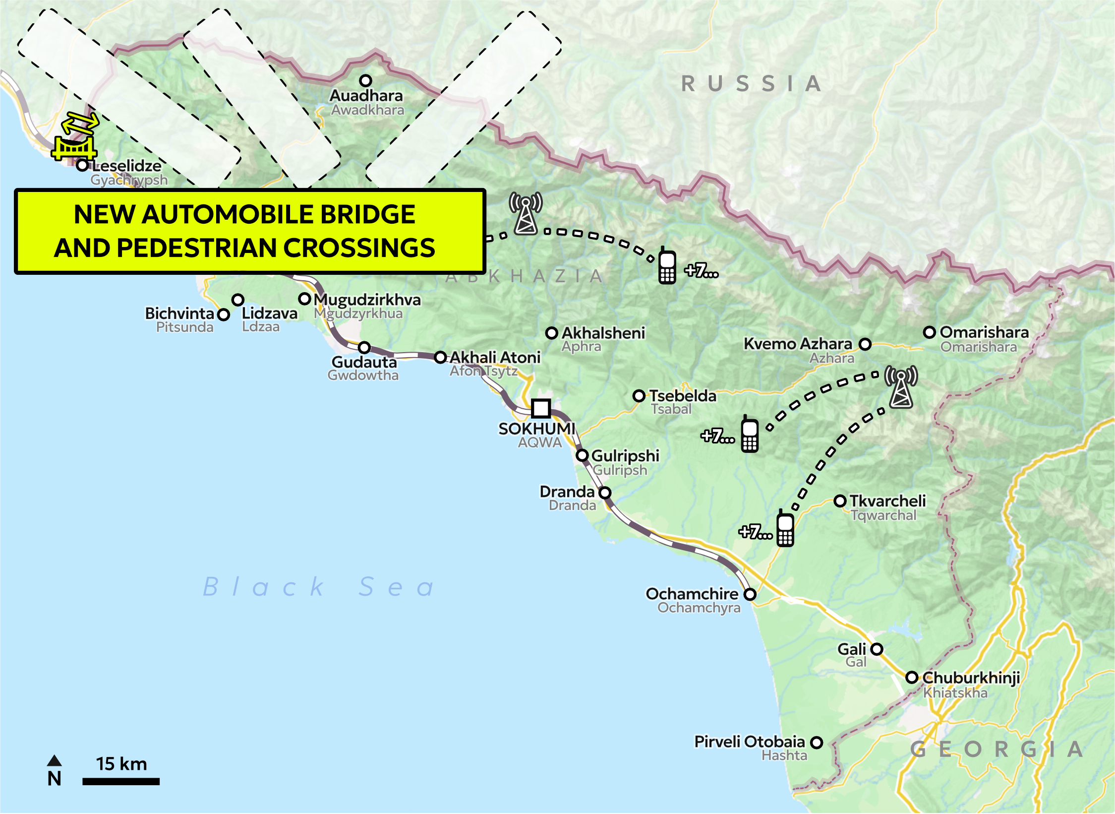
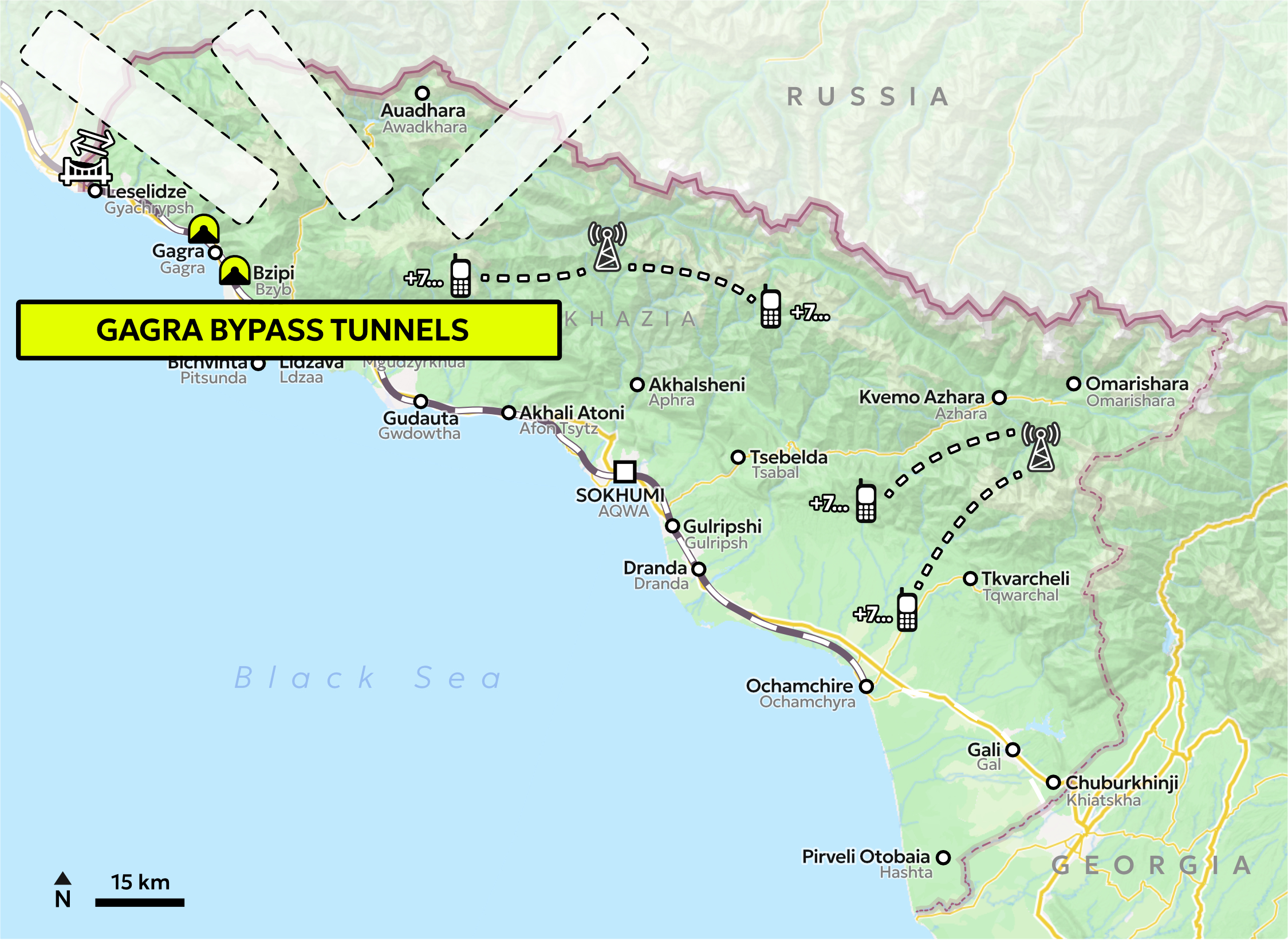
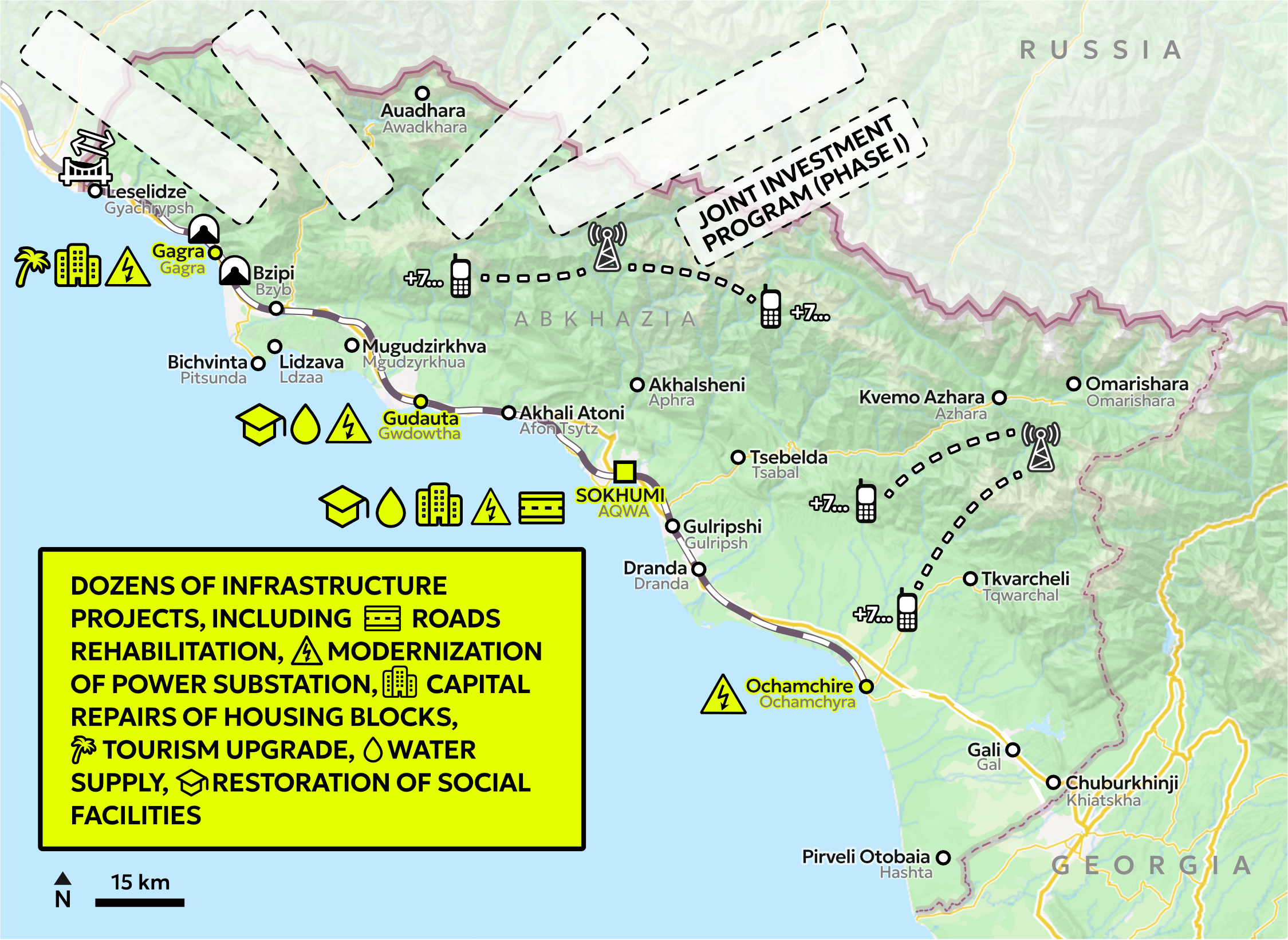
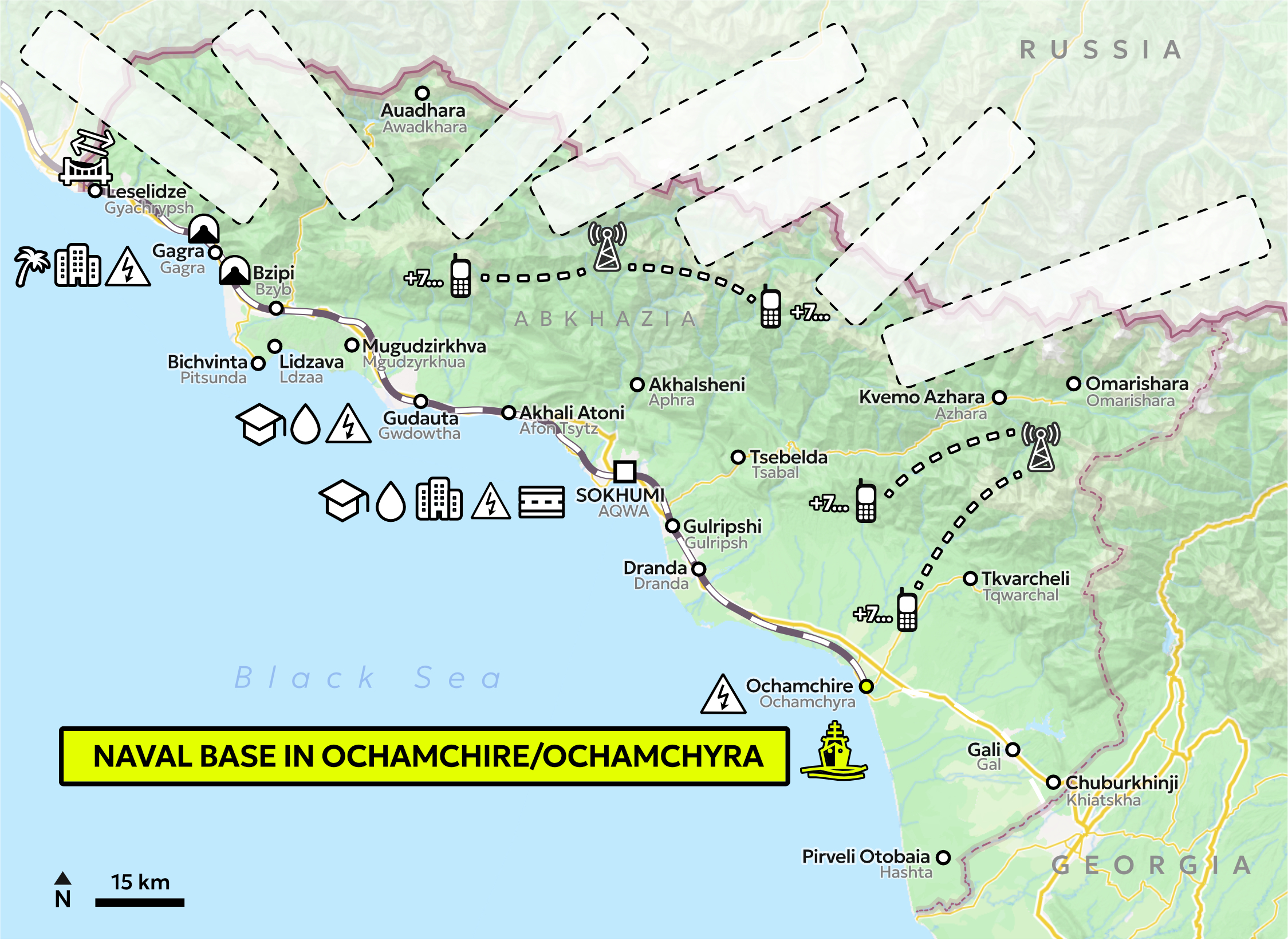
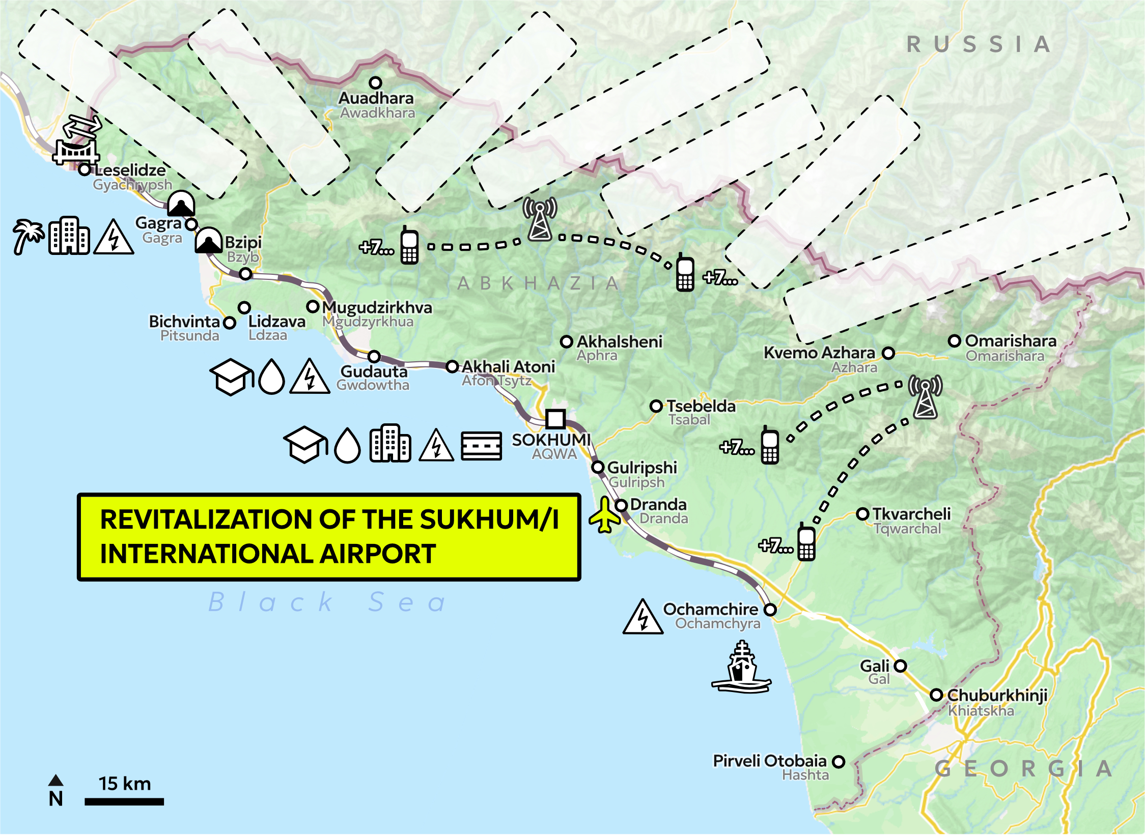
Patron-client relations appear, hence, as chokepoints over time. While we are able to capture infrastructure projects on a map, the underlying currents of the patron-client relations are much harder to visualise: long-term supply contracts, special legal regimes, military agreements, language and education policies, shared media ecosystems, training missions, or advisory programs. Rather than treating infrastructure projects as complete signs of interconnectedness and dependence within the relationship, we can read them as prompts that point towards what is off-map. Where we see a clear set up of interconnecting infrastructure (railway, airport, naval base) we can assume a corresponding, less visible mesh of credit arrangements, regulatory harmonization, diplomatic routines, and security guarantees.

Abkhazia-Russia Relations – Background Information
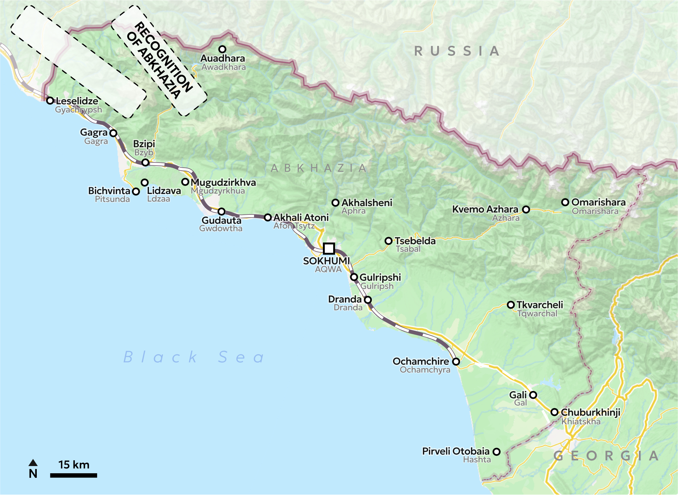
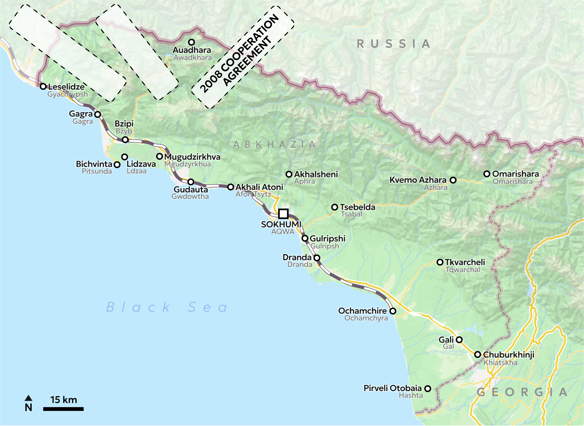
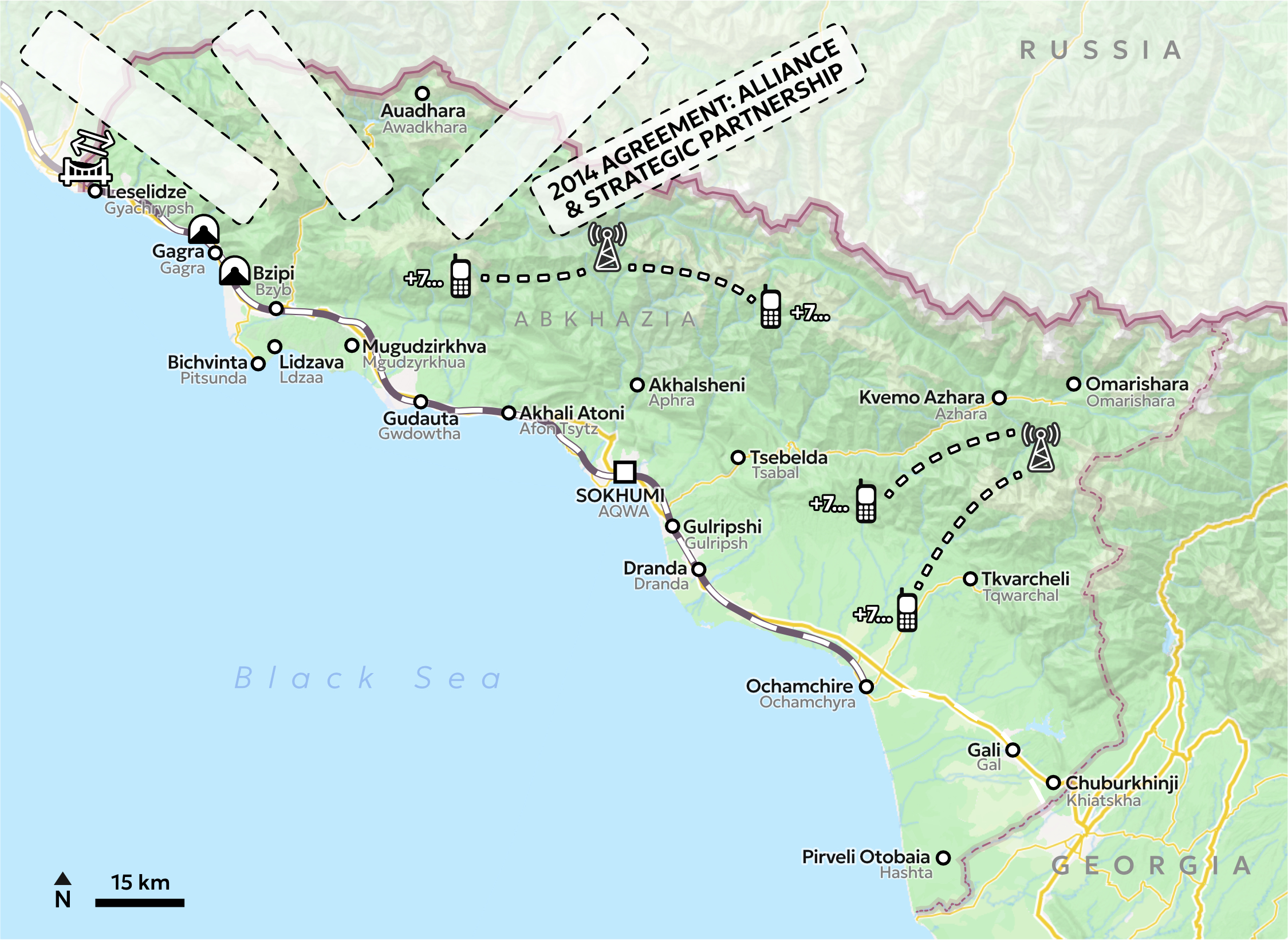
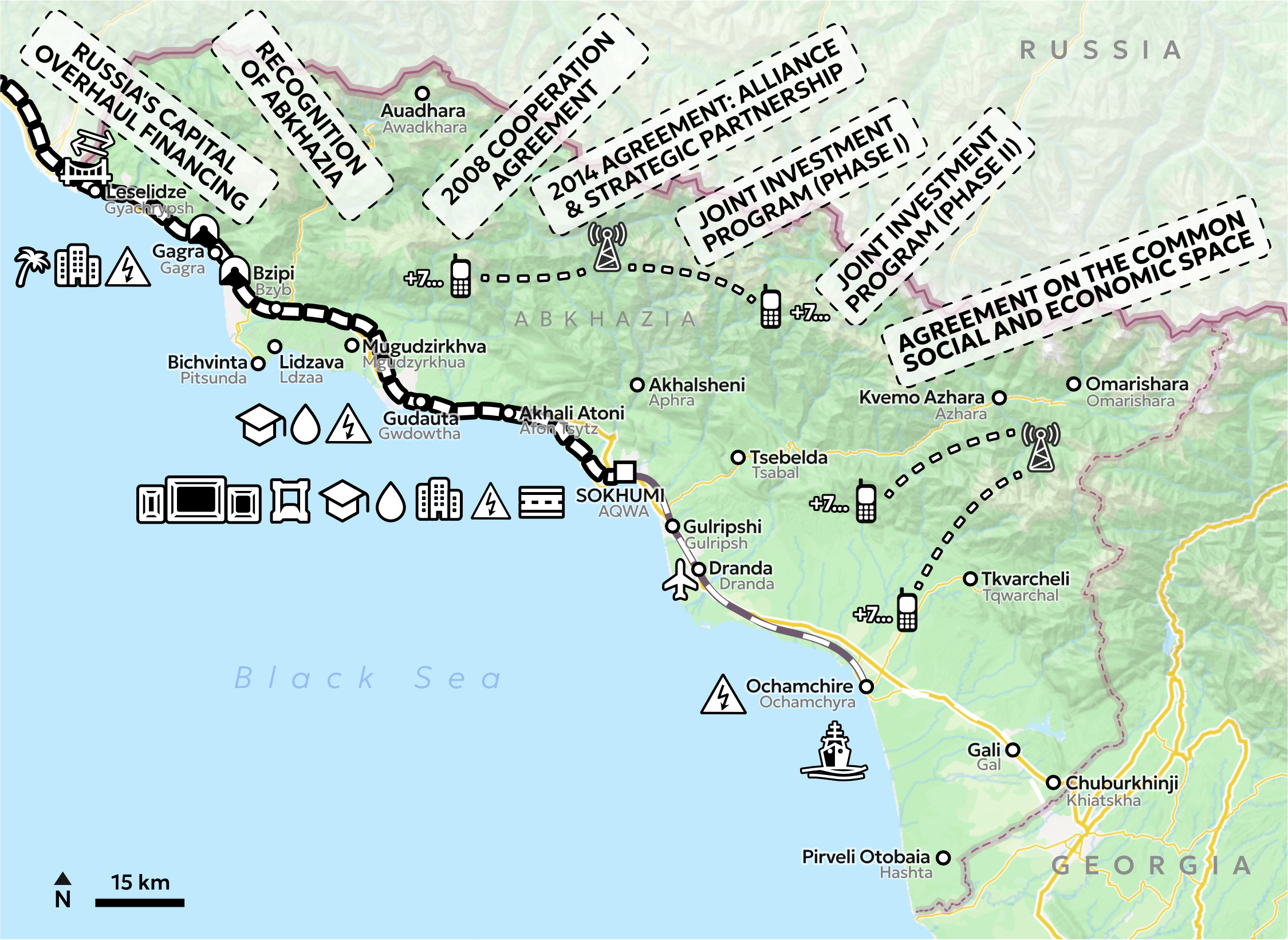
Following Abkhazia’s formal proclamation of independence from Georgia, the economy struggled to recover after the 1992–1993 war, which had destroyed infrastructure, displaced large segments of the population, and isolated Abkhazia internationally. While Russia supported Abkhazia militarily, its stance shifted when Georgia joined the Commonwealth of Independent States (CIS) in 1993 (Blakkisrud et al. 2021, 352). Russia subsequently joined the CIS embargo in 1996, thus intensifying Abkhazia’s isolation. During this period, trade with the Abkhaz diaspora in Turkey became one of the few links to the outside world (ibid., 350). Informal small-scale trade across the line with Georgian-controlled territory was also vital (Prelz Oltramonti 2015, 299). From 2000, Russia gradually eased the blockade (Berglund and Bolkvadze 2022). Yet, the relationship remained unstable, as illustrated by border closures and sanctions after the 2004 Abkhaz presidential election (Socor 2004). Relations were finally strengthened and consolidated when Russia officially recognized Abkhazia as an independent state on 26 August 2008, and a range of bilateral agreements followed. Significant benchmarks in this area include the 2008 Agreement in Friendship, Cooperation, and Mutual Assistance, the 2014 Agreement on Alliance and Strategic Partnership, and the 2020 Agreement on the Common Social and Economic Space. These treaties envision a close integration of the two economies with the goal of establishing a single market (Blakkisrud et al. 2021, 53). Belkania (2023, 295) argues that the 2020 agreement could pave the way to Abkhazia’s full integration into the Russian Federation. It’s “harmonization” agenda seeks to remove legal barriers in areas such as economics and finance, customs, the energy sector, and the social sphere, requiring broad alignment with Russian legislation (ibid., 301).
Since 2022, geopolitical shifts (Russia’s full-scale invasion of Ukraine in 2022, the collapse of Nagorno-Karabakh, and signs of Georgian-Russian rapprochement) have coincided with an increased integration with Russia. The 2025 presidential election in Abkhazia further points toward deeper economic alignment, likely reducing Abkhazia’s remaining room for maneuver vis-à-vis the patron.
Bibliography
Belkania, Badri. 2023. “The ‘Common Social and Economic Space’ Agreement Between Abkhazia and Russia: A Path to Russia?” Caucasus Survey 11 (2–3): 293–311. https://doi.org/10.30965/23761202-bja10021.
Berglund, Christofer, and Ketevan Bolkvadze. 2022. “Sons of the Soil or Servants of the Empire? Profiling the Guardians of Separatism in Abkhazia and South Ossetia.” Problems of Post-Communism, August 8, 1–12. https://doi.org/10.1080/10758216.2022.2102039.
Blakkisrud, Helge, Nino Kemoklidze, Tamta Gelashvili, and Pål Kolstø. 2021. “Navigating de Facto Statehood: Trade, Trust, and Agency in Abkhazia’s External Economic Relations.” Eurasian Geography and Economics 62 (3): 347–71. https://doi.org/10.1080/15387216.2020.1861957.
Lomsadze, Giorgi. 2023. “Georgian Worries over Planned Russian Naval Base in Abkhazia.” Eurasianet, October 11. https://eurasianet.org/georgian-worries-over-planned-russian-naval-base-in-abkhazia.
Prelz Oltramonti, Giulia. 2015. “The Political Economy of a de Facto State: The Importance of Local Stakeholders in the Case of Abkhazia.” Caucasus Survey 3 (3): 291–308. https://doi.org/10.1080/23761199.2015.1102452.
Socor, Vladimir. 2004. “Russia Blockading Abkhazia to Overturn Presidential Election.” Eurasia Daily Monitor, Jamestown Foundation, December 2. Volume 1, Issue 138 Edition. https://jamestown.org/program/russia-blockading-abkhazia-to-overturn-presidential-election/.
ABOUT THE AUTHOR
Lena Pieber joined KonKoop & ZOiS in April 2022 as a PhD-researcher. She studied international relations at the Diplomatic Academy of Vienna as well as international development and gender studies at the University of Vienna. Before joining ZOiS, she supported the EU Delegation to the International Organisations in Vienna and was working with the UN Women National Committee Austria and the Austrian Foreign Ministry. Her last position was Press Attaché of the Austrian Embassy in Moscow.
Roles
Author: Lena Pieber
Visualisation concepts: Iaroslav Boretskii and Mela Žuljević
Cartography: Iaroslav Boretskii
DataLab: Ivaylo Dinev
Advisor: Jana Moser
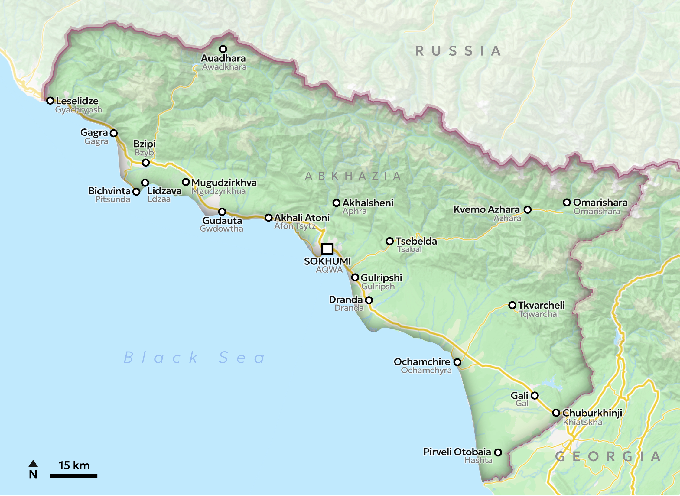
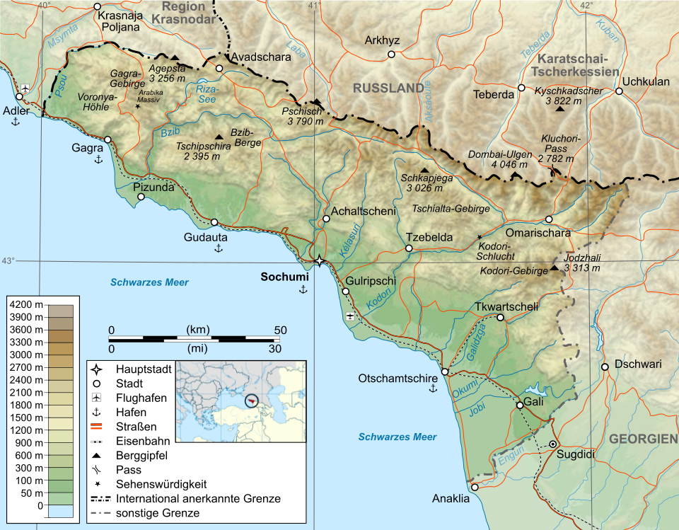
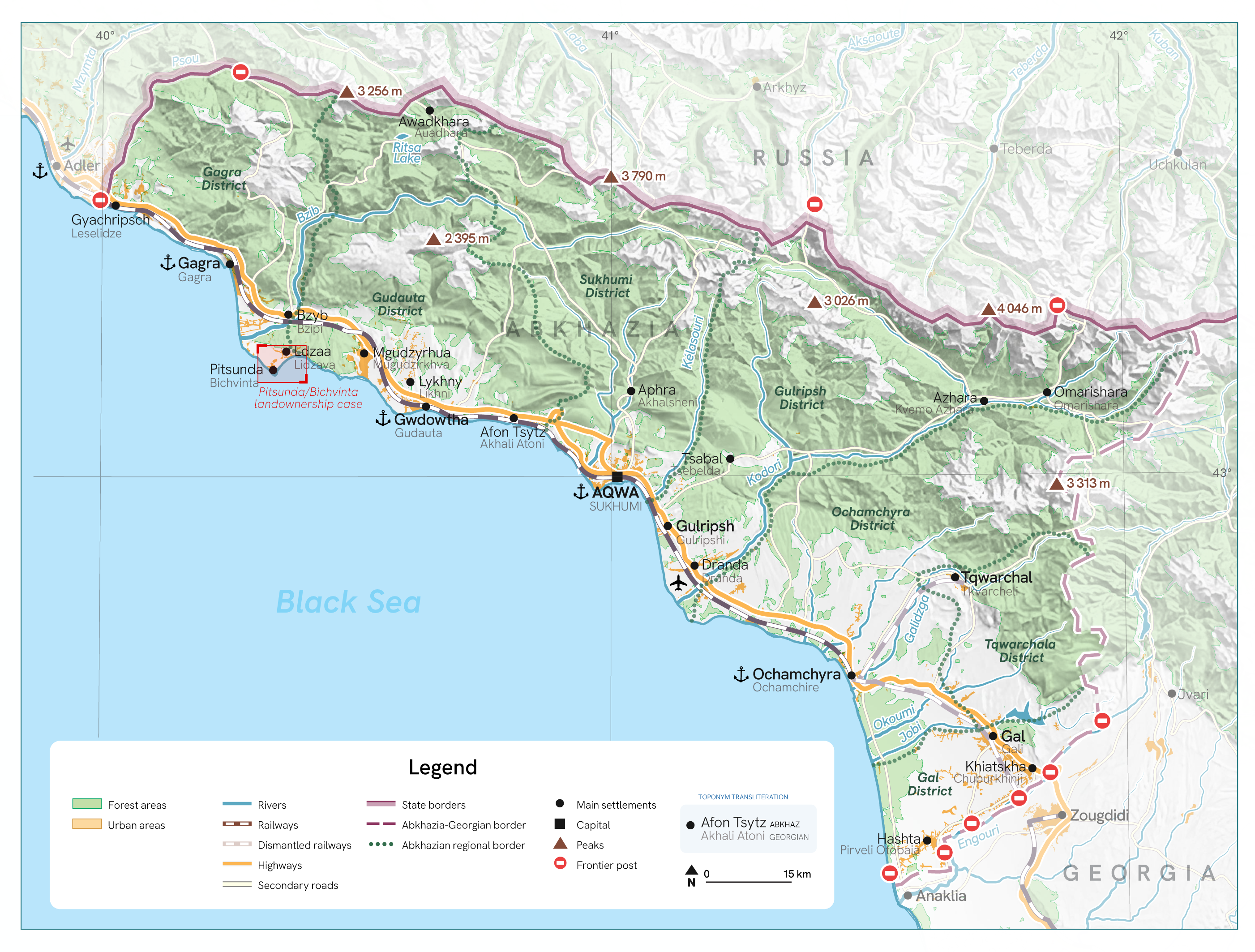
Iaroslav: Unfortunately, the original e-mail thread with the discussion on what exactly the map was supposed to show was lost. But likewise with many other map requests, Lena needed a more general overview map of Abkhazia, showing settlements, transport infrastructure, relief, and border crossing points (the data for the border crossing points was taken from OpenStreetMap). Technically I approached the mapmaking process through the juxtaposing and checking multiple maps from the web and adding needed data while restyling the existing SVG map of the region, link: https://de.wikipedia.org/wiki/Datei:Abkhazia_map-de.svg
Contested Place Name Labels
Although the restyling process was rather straightforward, the biggest challenge emerged within a process of visualizing the toponyms. The issue of place names in Abkhazia is particularly complex. The most prominent example of the naming option issue is demonstrated with the settlement of Novy Afon / Afon Tsytz / Akhali Atoni / New Athos, whose name has entirely different writings in four languages (Russian (with English transliteration of Russian name), Abkhazian, Georgian and English (with is a translation of Russian name). The question is simple: which one to choose?
Ultimately, the first version of the map followed the logic of displaying both Abkhaz and Georgian toponyms on the territory. However, the hierarchy between these languages in the labels was chosen primarily from the standpoint of visually distinguishing one language from the other, so that’s why top labels are more readable than bottom ones. Over time, however, by the stage of preparing the case for the atlas, such an approach inevitably brought a certain hierarchy into the way these toponyms stand. This can be seen in more detail in the email correspondence provided below.
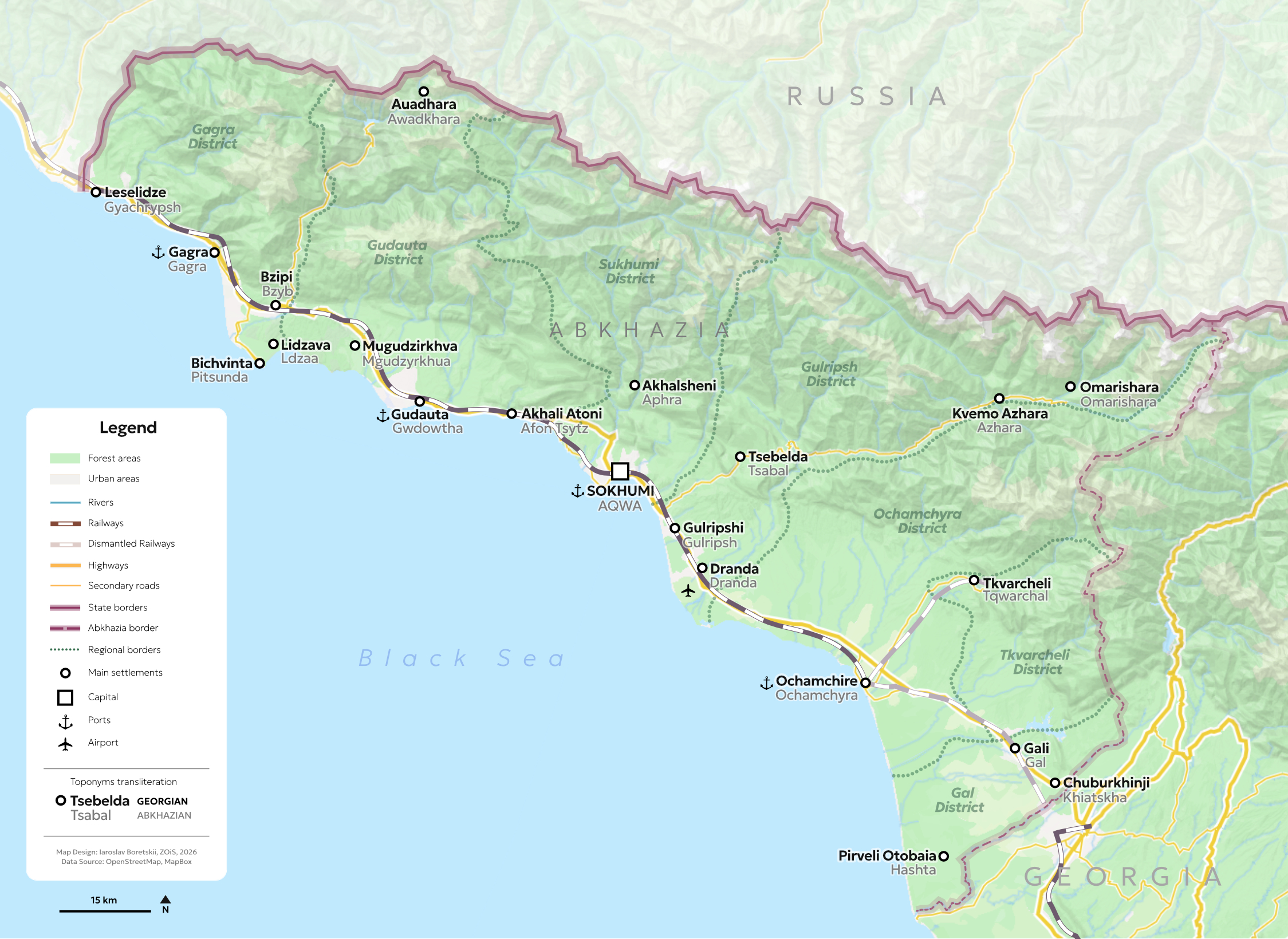
In the revised logic of the map, we came to understand that the first version tended to present Abkhazia more as an entity separate from Georgia, contradicting international law. For this reason, in the second version of the map it was decided to focus on presenting the Georgian name of each location as the primary one, while also including the Abkhaz name of the city in order to account for local linguistic particularities.
Finally, in order to demonstrate the diverse range of possible double labelling options, I developed a somewhat provisional matrix of different approaches that may be used for visualizing toponyms on a map.
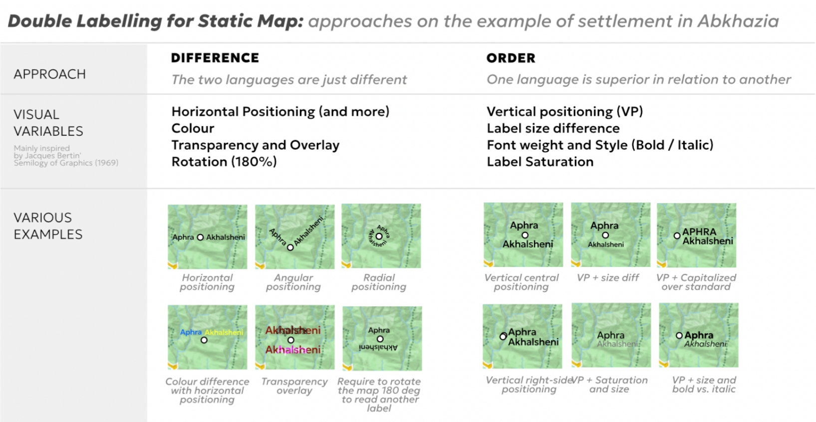
Mela: While these different label designs are very interesting and with lots of potential, I am not sure that the issue of hierarchy is addressed with the ones focusing on Difference. If one language appears first in the order of reading, it is already favoured. The radial positioning might be the one which manages to confuse this. Overlapping, as we tested in the case of Gäelle Le Pavic, might be something to add to this table. Combining different options is also interesting (for example, colour + positioning).
Then we continue with our email discussion:
Lena: We discussed the toponyms, but there are some more thoughts on this. I would like to share a feedback that I received: “the maps, as they are right now, create the impression that Abkhazia’s viewpoint is prioritized over the principles of international law” (part of Georgian territory). This is definitely not the intention. We have both toponyms, but I was wondering in which way we could highlight the Georgian version of the names? What do the two of you think?
Mela: I agree with the reviewer that it is a political choice on your side on which viewpoint you would want to put first. This is the issue of using multiple labels one above each other as it creates a hierarchy. In Gaelle's case, we are experimenting with overlapping labels but with international names as the most visible one. This works as her project is more ethnographic and it is about how the contested borderlines and territories appear in the field. Also, since she is looking at the borderline from the Georgian side, Georgian names in Latin script are preferred in the hierarchy and Abkhaz ones are only included for border crossing labels. In your case, however, you are presenting the economic agency of Abkhazia, so it might be important to keep the labels as they are with Abkhaz names preferred, with an inclusion of a statement clarifying that this position does not mean to challenge international law. But again, maps are expected to communicate quickly and clearly, so it is more important to take a clear political position.
Iaroslav: I would like to also add up some thoughts that maybe could become uncovered later in the reflection mode of the Atlas, but Lena, you can also just keep it for your records. The initial decision on the labelling, if I am not wrong, had nothing to do with the Abkhazia's viewpoint to stand out regardless of its belonging to Georgia in the first place. The main challenge obviously laid in this whole complexity of toponyms as a phenomenon. In particular, the case of Afon Tsytz / Akhali Atoni / Novy Afon / New Athos made it quite puzzling to decide what should be the solution to all other settlements' labels, considering that the map initially should've been published as an attachment for the article of the English-speaking academic journal.
The logic behind this solution was following: it is the Abkhaz people who represent the majority there (51%) as well as the Abkhaz language that serves as a dominant one in the extent of Abkhazia. Moreover, the Russian' influence was kept in mind as something that possibly alters the toponymic landscape (with the aforementioned settlement example) and makes it even more complicated when the toponym is translated fro, Russian name of the city to the direct English translation or it gets transliterated from Cyrillic to Latin in order to make it readable for English-speaking audience.
The hierarchy of the Abkhaz/Georgian language on the map, though, was not discussed as such between us back then, but the Georgian toponym was added there rather as a matter of respect to the international law, actually showing the initial connection between Abkhazia and Georgia on a different layer, not only from the notorious dashed borderline. Since the toponyms names are not always matching, the decision was to combine and prioritize the real experience of the place, but taking into account its legal affiliation with Georgia, as stipulated in international law. All of these seemed quite reasonable during the map-making process, in my opinion.
Lena: I am still thinking about how to best resolve the labeling issue. Historically, the issue is just very complex. I agree with much of both of your thoughts and I like the project of Gaelle, however, it probably won’t work for the maps in my case, as the overlaps might interfere with the images on infrastructure.
I guess the aim would be to find a visualization that remains consistent with international law while also making visible on the map that the naming of places in Abkhazia is disputed and contested. I therefore believe that a visualization in which both Abkhaz and Georgian place names are equally visible would work best, as this would reflect the politics of naming in a disputed territory.
In the long run, I am considering including all three toponyms (Abkhaz, Georgian, and Russian), but for that we would need to find a solution that works with the more “classic” map we are having, so as not to make it confusing. Perhaps the additional names could appear only when the user hovers over them? While it is true that my case focuses on Abkhazia, the aim of the paper is to highlight the interconnectedness and characteristics of its relationships with both Russia and Georgia, including their historical dimensions. In this way, I believe that foregrounding the different narratives and toponyms comes closest to capturing what I am trying to do in my work.
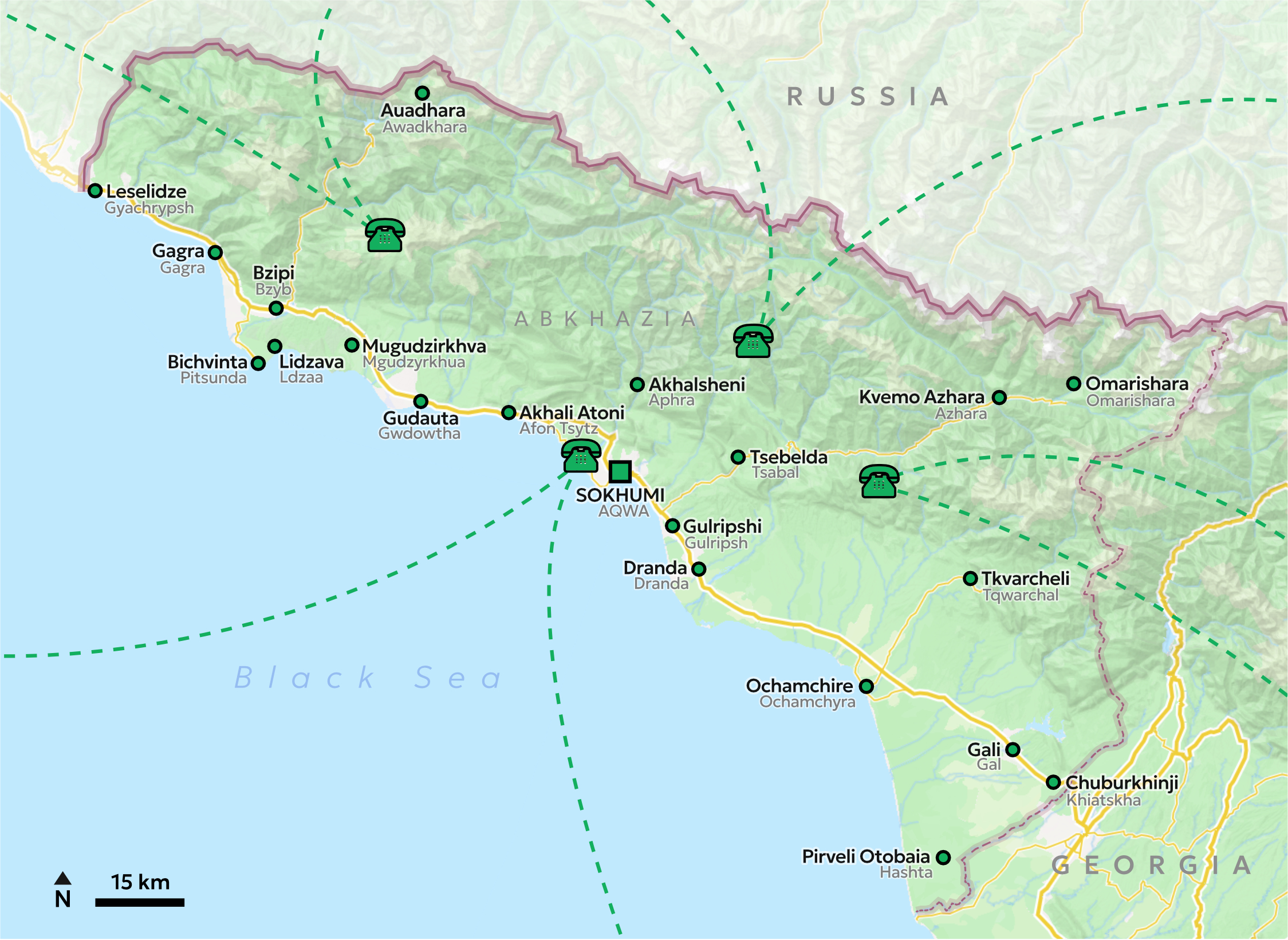
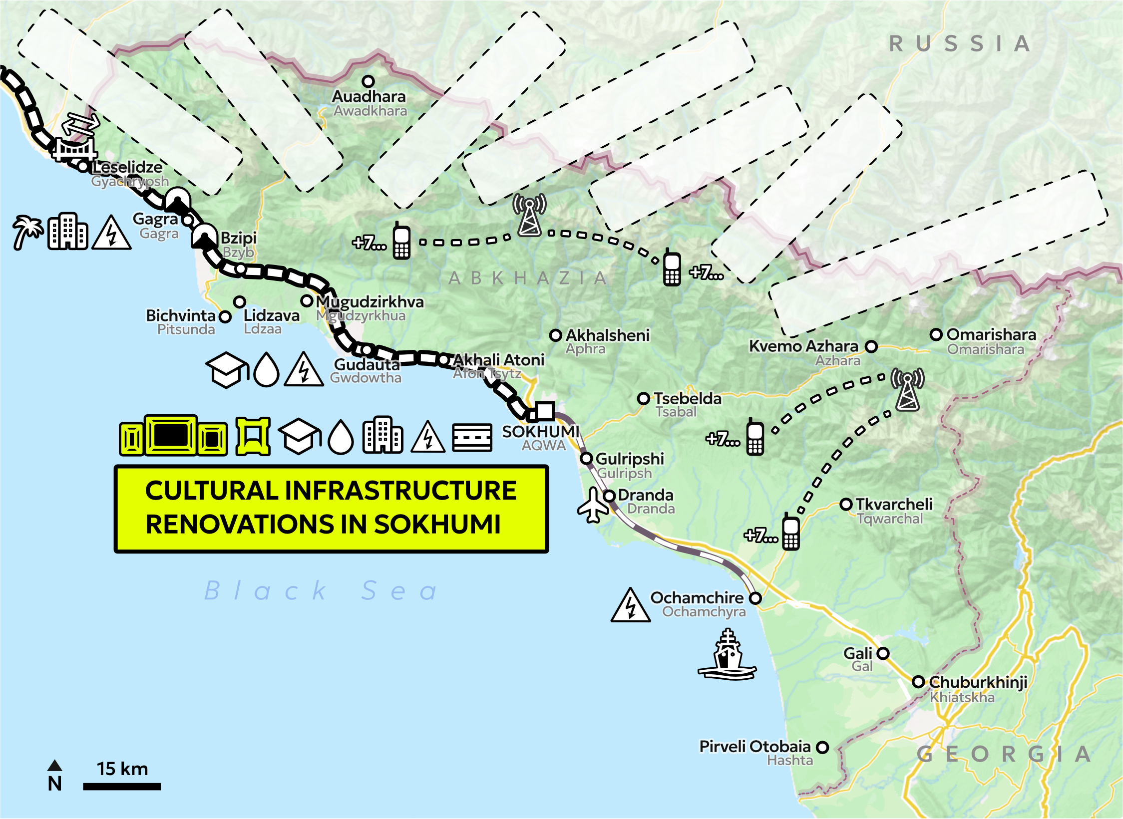
Showing 'invisible' infrastructuring
Mela: We wanted to indicate that there are visible marks of economic agency on the map, such as built infrastructure. But we also wanted to experiment with visualising the less visible aspects of economic agency - or less material ones, such as economic agreements while indicating that these can be difficult to trace and show. For this reason, we used an icon resembling ‘patches’ with labels which shortly appear to indicate an agreement, and then disappear again.
Lena: My only question is whether the names of the agreements could be placed at the side instead of directly on the map.
Or, maybe better: if we keep them “on the map”, I would suggest removing the “empty fields” reserved for contracts. It seems sufficient for contracts to appear only when they are actually shown, and then once more at the end. Keeping these empty fields visible throughout may be unnecessarily confusing for the viewer.
Mela: I agree that they turned out too visually “present” in the final maps - my idea was that the remaining patches would be a subtle sign of the agreement on the map, but now they look too overpowering. However we ran into an issue with the original files…. But we plan to adjust this in the next stages.
Iaroslav: While working on the timeline map sequence I ran into a rather unexpected, somewhat foolish, but at the same time very real problem connected to working in a local environment. Since I preferred to handle this project through vector files (Affinity Designer), I was working on them locally. Unfortunately, after a password change, I lost access to my work laptop and could no longer use the files there. Because of a very ordinary but consequential login error, I was effectively locked out of the laptop and had to erase all the data on the device in order to use it again.
This led me to a very simple lesson: it is absolutely essential to maintain a reliable connection between local work and cloud storage. By now, this issue has been resolved in my own workflow, and of course keeping backup copies of files is something that has long been considered standard practice. Still, even in 2026 I found myself running into exactly this problem.
So cloud-first, keep backups, write passwords, save iterations – essential workflow approach! It was a good reminder to have.