ABOUT THE CASE
Chernyakhovsk (formerly Insterburg) is a town in Kaliningrad area marked by a history of renaming streets and revising its urban memory. In this case, Elena Filippova traces the layers and stories inscribed in its palimpsest, while maps and visualisations articulates how these are distinguished as cartographic concerns, symbols and absences.
Introduction
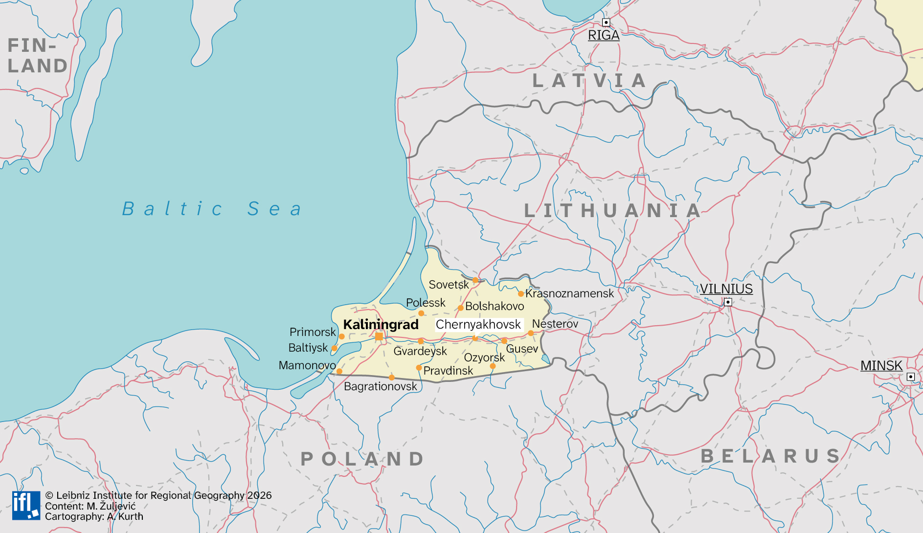
On the map, Kaliningrad Oblast looks like a mistake — a small wedge of Russian territory on the Baltic Sea, cut off from Russia by four hundred kilometres of foreign soil. It was German until 1945. Then its entire population was expelled, a new one was brought in, and roughly 1,500 place names were replaced. The buildings, though, stayed exactly where they were.
Walk the centre of Chernyakhovsk today and you are moving through a German city with Russian street signs: Prussian Gothic facades, Lutheran churches converted to Orthodox use, a medieval castle maintained by volunteers because the state owns it but will not pay for it. The city underneath the Soviet names has never quite disappeared. It persists in the brick, in the proportions, in the water tower on the main square whose facade still carries the initials of the Margrave who granted the city its civic rights in 1583. A court banned those initials from the city's coat of arms in 2019. It could not ban them from the water tower.
Andreas Huyssen described cities as palimpsests: texts continuously rewritten over their own past, where layers intersect, converge, and collide. Chernyakhovsk is one of the densest such palimpsests in Europe. Since 2022, the pressure to resolve this has intensified: an exclave ringed by NATO, squeezed by sanctions, subject to an increasingly aggressive campaign to erase what the bricks keep saying. What follows is an attempt to read what the city refuses to forget.
- When a state renames a place completely and permanently, what exactly does it rename — and what does it leave untouched?
- How does a city remember what it has been officially instructed to forget?
- What is the relationship between the power to name a place and the power to possess it?
- Can a place have a legitimate identity if that identity was imposed by administrative decree rather than accumulated over time?
How Maps Read a City
I am looking at three maps of Chernyakhovsk from different eras, and each of them is no less a political document than a geographical one. Each records a regime of visibility: what deserves to be named, what remains nameless, and who has the right to know where things are located.
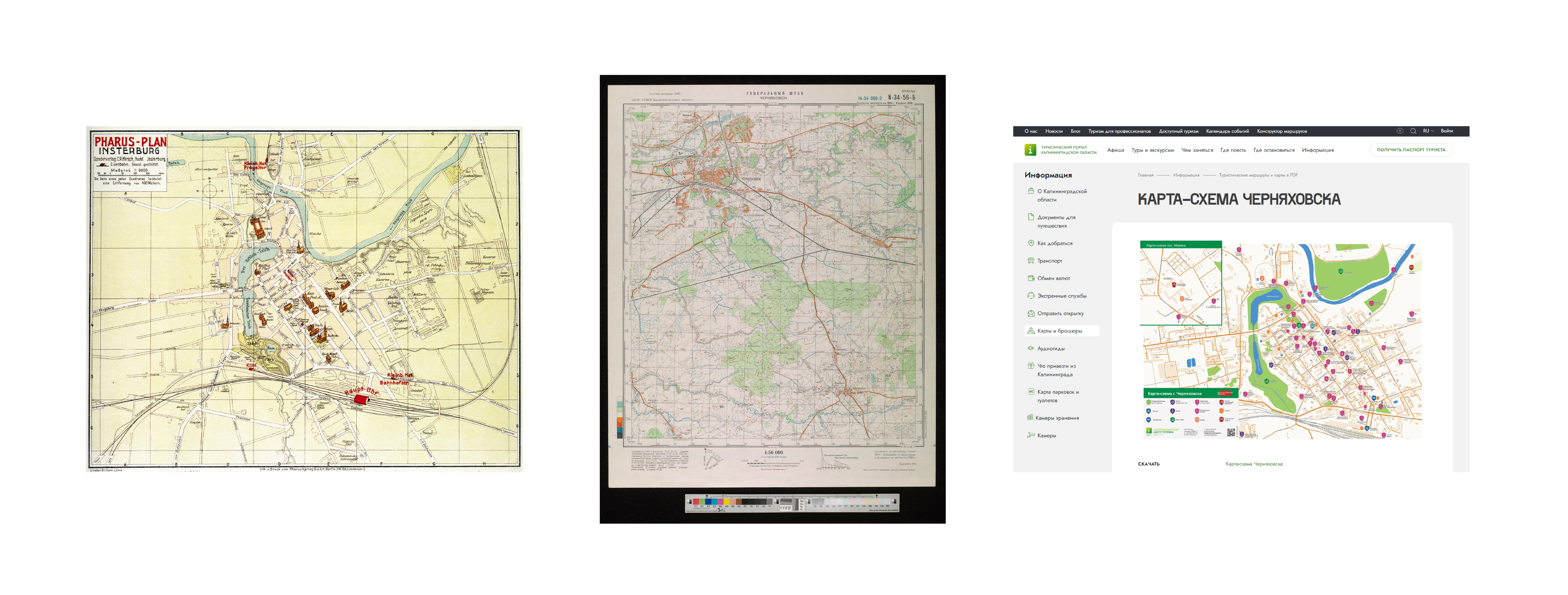
The Berlin publishing house Pharus-Verlag, founded in 1902, specialized in commercial city maps: dense, color-printed plans featuring isometric drawings of key buildings and an alphabetical street index. The very name refers to the Lighthouse of Alexandria and means to “show the way.” The Insterburg edition was made in 1920s.


To examine this plan is to look at a city confident in its own identity. The visual center is the confluence of the Angerapp and Inster rivers, which gave the city both its strategic position and its name. Insterburg Castle, founded in 1336 by the Teutonic Order’s Grand Master Dietrich von Altenburg, dominates the topographic composition. Four Evangelical churches and the monumental Reformed Church (1883–1890), with its three towers form the spiritual framework.
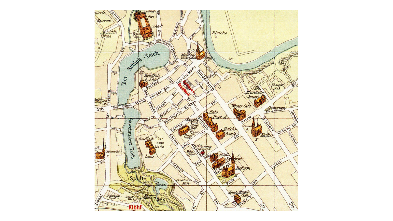
The Old Market and the New Market define the commercial space. The eastern district with its barracks and headquarters of the 2nd Division, housing more than two thousand soldiers, occupies a significant portion of the sheet. A railway hub with lines to Königsberg, Eydtkuhnen, Memel, and Allenstein, along with industrial enterprises a linen mill, an iron foundry, and breweries — complete the image of a prosperous Prussian Mittelstadt.
Yet the map reproduces only one layer and nothing beyond it. The Jewish synagogue in the city center is not marked. The Lithuanian-speaking population of the surrounding villages does not exist cartographically.
These are not accidental omissions. John Brian Harley wrote about “cartographic silences” not as errors or gaps, but as structural omissions that perform ideological work. The Pharus plan naturalizes a German bourgeois – religous protestant – military identity as a self-evident geographical reality. The dense labeling of every Straße, Gasse, Weg, and Platz produces what James Scott called a “legible urban text”: a space transparent to any newly arrived German speaker.
Soviet General Staff map Černjachovsk
A Soviet military map at 1:50,000 scale (series N-34) from the late 1970s to early 1980s shows a completely different space. The streets are unlabelled: only blocks, roads, building outlines. The German names had disappeared; the Soviet ones did not fit at this scale.
But around the city, on the sites of former German estates and farmland, appeared neat rectangles of allotment gardens labelled "Dachas", a characteristic Soviet transformation of the peri-urban landscape. The map itself was classified: the Soviet state did not permit its citizens to know the detailed topography of their own city. This was not just an administrative rule. Limiting access to spatial knowledge was part of what political scientist James Scott called the politics of “legibility”. The state sought to remain the only actor capable of seeing the whole map.
Карта-схема Черняховска
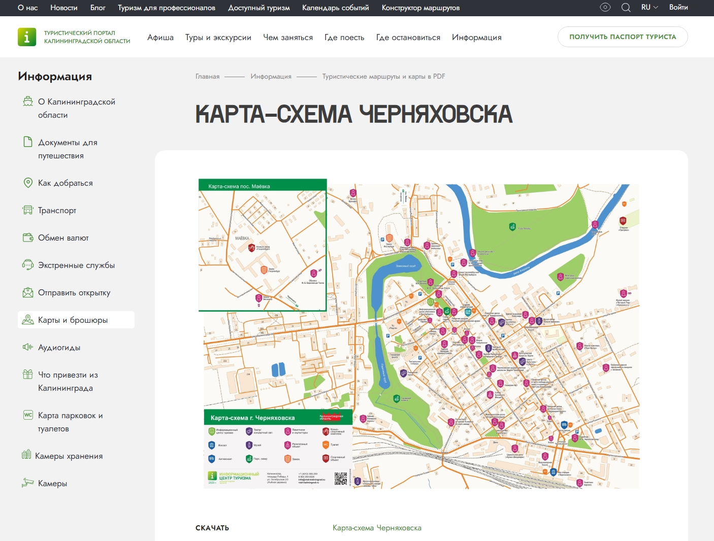
The contradiction is perhaps most legible in a single document: the official 2025 tourist map of Kaliningrad Oblast, published by the regional information centre at visit-kaliningrad.ru. Designed to be handed to visitors at airports and border crossings, it is by any measure, a German heritage map. Castles are listed under their historical names: Замок Георгенбург, Замок Гердауэн, Замок Прейсиш-Эйлау. Churches appear as «kirch» throughout. The word Insterburg appears on the official tourist infrastructure of the state that banned it from municipal heraldry. No explanation is offered for the inconsistency, because none is needed: the map is not a political document. It is a commercial one. The state bans the use of word Insterburg from its coat of arms and prints it on its tourist brochures. In that gap, the double naming survives.
1,500 Names: Renaming as Administrative Operation
The renaming of Kaliningrad Oblast was accomplished not in a single act but through a series of decrees over four years: from 1946 to 1950. The renaming of Insterburg to Chernyakhovsk took place by Decree of the Presidium of the Supreme Soviet of the RSFSR of 7 September 1946 "On the Administrative-Territorial Structure of Kaliningrad Oblast". The final mass act, liquidating the remaining German toponyms, was issued on 5 July 1950 — after the full deportation of the German population had already been completed. By that point the oblast counted more than 1,500 renamed settlements.
The first wave (1945–1946): translation as transitional erasure
Until the summer of 1946, the old German toponymy of the Königsberg region remained largely unchanged. The first changes came as early as November 1945: by order of K.N. Galitsky, commander of the Special Military District, 374 streets and squares of Königsberg were renamed as being "linked to the names of fascist leaders." In reality, only about fifteen streets in the city actually had such names.
No dedicated renaming commission was ever created. Proposals were prepared by civil affairs administrations and ratified by the Presidium of the Supreme Soviet of the RSFSR. Historian Yuri Kostyashov, who studied the declassified oblast archives, showed that the earliest renamings were largely literal translations — pragmatic rather than ideological. The state needed the postal service to function and the police to operate. Hence the use of semantic calques: the German word was translated into Russian, the meaning was preserved, while the marker of Germanness was erased.

Examples from Chernyakhovsk archives:
- Gartenstraße → ul. Sadovaya
A direct semantic calque: Garten means “garden,” and the Russian Sadovaya carries exactly the same meaning. The change replaces the German linguistic form while keeping the descriptive logic of the street name intact. - Tunnelstraße → ul. Tonnelnaya
Another literal translation, preserving the infrastructural reference. The name continues to indicate the presence of a tunnel or tunnel-like passage in the urban landscape. - Schloßstraße → ul. Zamkovaya
A straight semantic transfer from Schloß (“castle”) to zamok. The name maintains the spatial reference to the Insterburg Castle, a dominant landmark in the historical city layout. - Bergstraße → ul. Gornaya
A topographical translation: Berg (“hill” or “mountain”) becomes gora. The name keeps the reference to elevation or slope within the city terrain. - Königsberger Straße → ul. Kaliningradskaya
Here the change is administrative rather than linguistic. The reference to Königsberg is replaced by Kaliningrad, reflecting the new Soviet name of the regional capital. - Brauereistraße → ul. Zavodskaya
Not a literal translation. Brauerei means “brewery,” but the Russian name becomes the more neutral “factory street.” This slightly generalizes and depersonalizes the industrial reference, removing the specifically German urban-economic marker.
These renamings preserved semantic content while removing the linguistic marker of Germanness. The street means essentially the same thing it simply sounds Russian. This reflects Scott’s minimal operation of legibility: making the city navigable for settlers without yet imposing a strong ideological narrative.
The ideological layer emerged later, as settlers and local authorities began proposing new names drawn from Soviet heroes and the regions from which the newcomers had arrived. As Kostyashov documented, familiar names from distant parts of the Soviet Union appeared across the former East Prussian landscape: Vladimirovo, Moskovskoye, Kaluzhskoye, Yaroslavskoye. In the Chernyakhovsk district specifically, the pattern is legible on any contemporary map: the village of Grünheide became Kaluzhskoye, after the Kaluga region from which many settlers had come. Georgenburg was renamed in Petrozavodskoye, after the city of Petrozavodsk — itself named after Peter the Great's arms factory. Fragments of a mental geography carried by settlers and transplanted onto an unfamiliar land. The territory was being literally reassembled from pieces of Soviet space.
The second wave (1947–1950): ideological rewriting
The second wave was systematic. German cultural and military figures were replaced with Soviet equivalents, and ideological toponyms were introduced without any semantic connection to the original names. Across the region, the map filled with the names of revolutionary heroes, proletarian leaders, Russian military commanders, writers, and scientists. Some settlements were named after the places from which the settlers had come: Vladimirovo, Izhevskoye, Mordovskoye, Moskovskoye — fragments of a mental geography transplanted onto unfamiliar land. The territory was literally reassembled from pieces of Soviet space.

In Chernyakhovsk itself the result of this logic is visible with surgical precision. Hindenburgstraße, the main artery running from the Alter Markt to the station, became Ulitsa Lenina (Lenin Street). Wilhelmstraße, lined with German villas, had been named in 1874 by decree of the Insterburg magistrate. Deutschestraße — "German Street" became Ulitsa Krupskoy, Lenin's wife. Friedhofsweg — "Cemetery Road" became Ulitsa Dzerzhinskogo, after the founder of the Soviet secret police. The dark logic is hard to miss: the path to the cemetery named after the man who sent so many there. The semantic content of these renamings is not random: some evoke the victories of 1812, others revolutionary heroes, others simply cities thousands of kilometres away. Read together, these renamings form a political programme grafted into the city's address grid.
Yuri Buida in his novel "The Prussian Bride" captures this moment through a concrete episode: a woman travels to the city of Wehlau, and right on the station platform workers are painting over its name on the signs. That same night she and her friends speculate about what the city will be renamed. Her suggestion — "Nowhere" — is rejected as insufficiently Russian. The city became Znamensk — from the word for "banner". This anecdote conveys the essence of what was happening more precisely than any academic description: renaming as the production of a new reality from nothing.
The errors and curiosities of the process are no less revealing than its intentions. Thousands of names had to be invented under time pressure, recorded in documents, and reproduced on signs and plaques not just in Chernyakhovsk, but across the entire former East Prussian territory that had become Kaliningrad Oblast. In the rush and in the absence of anyone who might have cared the map filled with names that were repetitive, bland, and interchangeable. The region ended up with five settlements called Lesnoye, five Zaitsevo, six Dubrovka, seven Beregovoye, nine Oktyabrskoye. The absolute record was held by Sosnovka (Pine Grove ), which appeared twelve times across the former Prussian landscape. A territory that had spent six centuries accumulating a dense, specific, legible toponymy was overwritten in four years with a map that could have belonged anywhere in the Soviet Union. That, in a sense, was the point.
After 1991: a non-event
In Chernyakhovsk, the collapse of the Soviet Union changed nothing. The Soviet street names remain fully in force. There has been no documented attempt to restore German names. A 2019 federal grant for the restoration of the "historic quarter" along Ulitsa Lenina, Ulitsa Kalinina, and Ulitsa Sadovaya embraced the prewar architectural heritage while leaving the Soviet toponymic layer untouched, a material palimpsest frozen in administrative amber.
The renaming of 1946–1950 had nothing to overwrite. There was no Russian layer underneath — only German. When other post-Soviet cities restored pre-revolutionary place names, Kaliningrad Oblast had no such names to restore. The only alternative to the Soviet layer is the German one. This is what explains the intensity of the identity-stabilisation campaign: every loosening of the Soviet layer exposes not a "neutral" past, but a directly German one.
Two Routes, One Erasure
A map fixes space. An excursion gives it a voice. But what is said — and what is deliberately left unspoken — turns out to be no less political than Harley's cartographic silences.
The excursion was not an accidental choice of format. Soviet Researcher Jamie Freeman has shown, city guides were conceived by the authorities as "propagandists of knowledge" — people capable of turning physical space into a legible Soviet narrative. The Kaliningrad Excursion Bureau developed its routes in accordance with a direct ideological brief: to help new settlers appropriate a territory they had not chosen and did not know. Lectures, routes, stops at monuments — all of this was part of what the region called the "mastering of the homeland", in which ideological work and tourist infrastructure were inseparable. The excursion did what a renamed street sign could not: it gave voice to space and explained what had happened here. And, crucially, that nothing had happened here before 1945.
The Soviet excursion (1966–1967): history begins in 1945
The "Kaliningrad–Kaunas" bus excursion — a 48-hour route covering approximately 600 km through Gvardeysk, Znamensk, Chernyakhovsk, Gusev, Nesterov, and on to Kaunas passed through a region where even Soviet citizens required special authorisation to enter. In Chernyakhovsk, the excursion stopped at the bust of General Chernyakhovsky at Station Square.


The Bureau's methodological materials instructed guides to convey the following:
- Chernyakhovsk has a population of over 30,000 and serves as a significant railway link.
- The city has received its modern name in honour of the outstanding Soviet Commander, twice the Hero of the Soviet Union, General Ivan Danilovich Chernyakhovsky.On February 19, 1945, when the Soviet armies had already smashed Hitlerites on their approach to Königsberg, I. D. Chernyakhovsky was fatally wounded near Melzak and buried in Vilnius. The bust of the outstanding commander is placed at the Station Square in Chernyakovsk.
- In the city, approximately 20 industrial enterprises work. Among them … car repairs, confectionary … meat-processing plants, milk plants and a cheese plant.
- The city is the cultural centre of the area. In the city there are three movie theatres, some recreation centres, ten red corners and libraries. Under construction is a new 600-seater movie theatre and new schools – both pedagogical and professional – for the study of music, art and sports.
- In 1966, construction began on many six-storey houses and a hostel for pupils. Radical reconstruction of the water supply is due to be carried out, where two deep wells will become operational and a heating plant will be built.
- Redevelopment of the city stadium and the swimming pool on the river bank has also begun, and the city will soon be intensively planted with trees and shrubs.
The emphasis was deliberate. Soviet urban planning held as a founding premise that matter determines consciousness that to change how people thought, you first had to change their material surroundings. Reconstructed buildings and new infrastructure were not simply practical achievements; they were, as Freeman notes, "symbols of progress and economic strength", each new building hailed as another victory for Soviet city-building. In Chernyakhovsk, where the prewar built environment had survived largely intact, this logic acquired an additional urgency: the new had to be made visible precisely because the old was so stubbornly present.
What the instructions did not contain was any mention of what the city had looked like before 1945. German architecture was physically everywhere: Chernyakhovsk had retained around 70% of its prewar building stock, far more than the bombed-out Kaliningrad, but discursively nonexistent. Buildings were referenced only through their Soviet function: "the school", "the hospital", "the factory". The Lutheran parish church on Lenin Square, built in 1610–1612, was still standing — it would be demolished in 1972. The castle stood in ruins, unmentioned.
The school excursion (2024–2025): the eternal road of the Russian soldier
The route "Chernyakhovsk: Road of the Russian Soldier", developed by School No. 6 for pupils in grades 5–11, frames the city through four wars in which "the Russian soldier" fought on this territory: the Seven Years' War (1757), the Napoleonic Wars (Barclay de Tolly died near Insterburg in 1818), the First World War, and the Second World War. The route's official documentation lists its goals: to cultivate "patriotic consciousness", "spiritual and moral development", "military-patriotic education" — vocabulary drawn straight from the federal civic curriculum that has hardened since 2014 and is now, after 2022, close to mandatory.
Kaliningrad Oblast is a Russian exclave surrounded by NATO members, cut off from the Russian mainland, and populated by people whose connection to "Russian" history on this land is, at most, three generations deep. The German built environment constitutes the everyday visual experience of the region: its street grids, its school buildings, its castle ruins. In this context, Russian territorial identity is not a given; it requires continuous construction. The school excursion is one of the institutional mechanisms through which this construction is carried out.


The castle is included in the route, but stripped of its Teutonic Order history. On the commercial platform Tripster, a related excursion promises "a journey along the roads of Russian military glory to the former borders of the Russian Empire". It is telling that the diorama of the Battle of Gross-Jägersdorf (1757) is housed inside Insterburg Castle: a Russian military victory exhibited inside a German fortress, the container absorbed by the content. The building's origin is beside the point. "The Russian soldier" was here — and this is therefore Russian ground.
The Soviet excursion instructed guides to recite industrial statistics and say nothing about the German past. The 2025 school excursion does not suppress the German past — it appropriates the space around it: the castle as scenery, the Teutonic history as silence, the Russian military arc as the only thread connecting past to present. The guide is no longer a "propagandist of knowledge" in the Soviet sense. But the function is the same: to make a child standing in a 14th-century German fortress feel that they are standing on Russian soil.
-
Monument ID Chernyakhovsky: During the excursion, students and teachers will pay tribute to the commander of the 3rd Belorussian Front, General of the Army Ivan Danilovich Chernyakhovsky, under whose command Soviet forces stormed the German city on 22 January 1945. The heroes' glory is marked by Soviet-era monuments: the monument to General Chernyakhovsky and a memorial plaque to the Normandie-Niémen air regiment — our allies — which was based at a nearby airfield
-
Monument to Barclay de Tolly: Students will learn about the foreign campaign of the Russian Army under the command of Field Marshal Barclay de Tolly during the war against Napoleon. A monument to the Russian commander stands in the city square.
-
Memorial Plaque to the Sisters of Mercy: The group proceeds along Suvorov Street to School No. 6, on the wall of which a memorial plaque is affixed to the Sisters of Mercy. The plaque was installed in Chernyakhovsk in 2014 on the building of the former Boys' Secondary School. A high relief depicting two Sisters of Mercy is mounted on the facade, with the inscription: 'Dedicated to the Sisters of Mercy.' Below it, a plaque reads: 'During the First World War, in August–September 1914, this building housed a mobile field hospital of the Marble Palace of the Russian Red Cross Society attached to the 1st Army, where Grand Duchess Maria Pavlovna (the Younger) (1890–1958) and Princess Elena Petrovna (née Princess of Serbia) (1884–1962) served as Sisters of Mercy.
-
Castle Insterburg: Additional visits are available to Insterburg Castle (founded in 1336, around which the city developed).
What changed, what remained
The Soviet excursion stabilised identity through temporal rupture — history begins in 1945. The 2025 school excursion stabilises it through temporal depth: Russian presence on this territory stretches back 270 years, through four wars, making the current ownership appear not as a postwar anomaly but as the culmination of a long arc. This is a classic device of memory politics: what Huyssen called the conversion of the contingent into the primordial — the rewriting of contingency as destiny.
In their treatment of architecture, both approaches do the same thing: they turn German buildings into a silent backdrop. In 1967, the guide looked straight through them. In 2025, the castle is on the itinerary, but its history is not. The difference is that the silence has become intentional: the backdrop is absent not because no one sees it, but because someone decided not to name it.
"Elements of Foreign Culture": The Fate of the Coat of Arms
The politics of memory in Kaliningrad Oblast has always been unstable. In the 1990s and 2000s there was an East Prussian renaissance: local researchers, German-Russian cultural exchanges, local history. Then, from 2014 onward, came the backlash: state television began speaking of "creeping Germanisation"; the German-Russian House in Kaliningrad was designated a "foreign agent" and effectively closed. In November 2018 vandals doused the Kant monument with pink paint; leaflets read: "Shame on traitors! Shame on Kant! Glory to Rus!"
In 2019 this logic received legal expression through what appeared to be a minor case. The Chernyakhovsk prosecutor's office filed an administrative suit against the city's coat of arms: the very one adopted in 2002 on the basis of the historical arms of Insterburg. The arms showed a Prussian bear on a mountain and the Latin initials "G.F." — those of Margrave Georg Friedrich, who granted the city its rights in 1583. On 16 September 2019 the Chernyakhovsk City Court upheld the suit in full. The legal basis was Federal Law No. 53-FZ "On the State Language" (2005) and the methodological recommendations of the Heraldic Council under the President, prohibiting letters in scripts other than Cyrillic in municipal symbols.
The asymmetry is worth noting: those same initials "G.F." remain to this day on the relief of the 1898 water tower: it is a listed heritage object and falls outside the same ruling. The court could rule on a coat of arms. It could not rule on a water tower.
The Internet Remembers Both Names
Against the official campaign, the internet has become a durable space of double memory. This persistence is structural: decentralised archives have no mechanism for forgetting.
The site angrapa.ru — the main Russian-language local history resource on Chernyakhovsk — is organised simultaneously under both “Chernyakhovsk” and “Insterburg”. This bilingual structure is itself a statement: sections consistently use the dual name and map German and Soviet street names using materials from Insterburger Brief and the almanac Shores of the Angrapa.
The same logic extends to infrastructure. For years, the official district administration website operated at inster39.ru, referencing both Insterburg and the River Inster. After 2022, a parallel, neutral address – che.gov39.ru was introduced. Both remain active: inster39.ru still functions, and official email addresses continue to use it.
This coexistence shows how two names of the same city persist within a single system and how difficult it is to erase one of them.
What Remains
What makes Chernyakhovsk a special case is not the familiar post-Soviet logic of renaming, replicated across the former USSR. What sets Chernyakhovsk apart is the totality of the replacement: approximately 1,500 names in four years, with not a single pre-Soviet Russian toponym to which one might return. When other cities of the former USSR restored pre-revolutionary names, in Kaliningrad Oblast this option did not exist. The renaming of 1946–1950 didn’t replace an earlier layer; it marked the beginning of a Russian one laid over the German past.
The physical impossibility of erasing the German environment creates a permanent tension and perhaps it is this that explains the growing intensity of official campaigns. The more evident the mismatch between official names and the visible environment, the more effort is required to maintain it. The physical city would not change. So the pressure moved to what could be changed — symbols, seals, official documents. The 2019 coat-of-arms case was the result.
What will happen next is unclear. Will German traces continue to disappear under the pressure of policy, or will their tourist value become an argument in their favour? Will the double naming survive in digital archives if pressure on the internet intensifies? Can a city with such a history arrive at a stable identity at all — or is this very instability its true nature?
Yuri Buida formulated it with a terseness I cannot improve on: "My homeland has a German past, a Russian present, and a human future."
The map below (produced by Anja Kurth) bring together the different streets and places mentioned in the article to trace the changes across time (if the small texts are cut off on your screen, please zoom out the map to ensure readability).
Bibliography:
-
Decree of the Presidium of the Supreme Soviet of the RSFSR of 7 September 1946 "On the Administrative-Territorial Structure of Kaliningrad Oblast".
-
Federal Law No. 53-FZ "On the State Language of the Russian Federation", 1 June 2005. consultant.ru
-
Geraldika.ru. Coat of arms of Chernyakhovsk, registration No. 961.
-
Kaliningrad.Ru. Alikhanov: Kant is a Russian trophy for us. 22 April 2024.
-
DW. The International Kant Congress was relocated from Kaliningrad to Bonn. 2024.
-
Meduza. Kant monument doused with paint in Kaliningrad; leaflets distributed. 27 November 2018.
-
Digital Archives and Official Sites
-
Local history resource angrapa.ru (Chernyakhovsk / Insterburg).
-
Official site of the Chernyakhovsk district administration (historical domain). inster39.ru
Literature
-
Buida, Yu. The Prussian Bride. Moscow: Novoye Literaturnoye Obozreniye, 1998.
-
Knappe, E. Der Transformationsprozess in der Region Tschernjachowsk. Berliner Geographische Arbeiten, 1994. (IFL library)
-
Kostyashov, Yu. V. Secret History of Kaliningrad Oblast: Sketches 1945–1956. Kaliningrad, 2009.
-
From German Königsberg to Soviet Kaliningrad Jamie Freeman, BASEES, 2022
-
Harley, J. B. The New Nature of Maps: Essays in the History of Cartography. Baltimore: Johns Hopkins University Press, 2001.
-
Huyssen, A. Present Pasts: Urban Palimpsests and the Politics of Memory. Stanford: Stanford University Press, 2003.
-
Identität und Stadtentwicklung in Kaliningrad: raumbezogene Identität, Geschichte und symbolische Architektur in der aktuellen Stadtentwicklung in Kaliningrad. Michael Weichbrodt (IFL library)
-
Die Landschaften Ostpreußens Herbert Liedtke (IFL library)
-
Костяшов Ю. Советизация Восточной Пруссии после войны // Mažoji Lietuva: paribio kultūros tyrimai. Vilnius, 2012. Р. 183-206.
ABOUT THE AUTHOR
Elena Filippova is a media and editorial professional working in journalism and cultural storytelling since 2016. She specialises in educational journalism, editing, and digital formats — from longform features to short-form video and social media series. She produced and curated 15+ digital projects across culture, memory, human rights, and inequality, often bringing a postcolonial lens to questions of territory and identity. Her work includes an award-winning project on resource colonialism (Profession: Journalist Award 2025).
Roles
Author: Elena Filippova (journalist fellow at Leibniz IfL in 2025/26)
Visualisations: Mela Žuljević
Advisor: Jana Moser
Cartography: Anja Kurth
In the case of fellowships at IfL, these reflections summarise the series of conversations we've had with the authors. They are mostly focused on diving deeper into the research or artistic approach of the fellows, and less on the individual steps of the visualisation process. We condense and represent multiple groups discussions as snippets of conversations between the VisLab and the fellow.
VisLab: Elena, our conversation started with your fellowship at IfL and some interesting questions on how to navigate between a journalistic, cartographic and academic perspective in telling the story of Kaliningrad urban memory. Could you reflect a bit on the starting ideas you had and how they changed after our first discussions?
Elena: I had been interested in Kaliningrad Oblast for quite a long time before the fellowship. It was one of those places I had mentally marked as: this is extremely interesting, and I want to understand it better. But when I wrote my initial proposal for IfL it was still very broad. Looking back, I can see that I was trying to cover too much at once.
What really changed after our first discussions was the research perspective. I am used to approaching topics as a journalist: reading sources, articles, reports, and then building the story from there. But you suggested starting from the material itself, especially from the maps in the IfL library.
That was very helpful. Instead of doing more background research immediately, I simply started looking at maps from different periods. And when I came across Chernyakhovsk, it suddenly felt like the perfect case: one city where questions of renaming, memory, Sovietisation and the German past all intersected. In the article, this became a way to look at what different maps make visible, what they leave unnamed, and how political power is embedded in cartography.
The most important shift was probably the change of scale. I realised I did not need to explain the whole Kaliningrad region. One specific city could make much larger processes visible much more clearly.
VisLab: You had the chance to engage with many maps and cartographic perspectives during your fellowship. How did these affect your understandings of urban memory, identity of power?
Elena: For me, this opened up a completely new way of looking at cities. I had never worked with so many maps before, or approached them as analytical objects rather than neutral representations of space.
What I found especially useful was learning to ask different questions: what a map makes visible, what it leaves out, what language it uses, who it is made for, and what purpose it serves. The Critical Map Reading approach also helped me think about silenced perspectives, framing, and the political context of map production.
I think this is especially important in contexts like the Soviet Union, or contemporary Russia, where verbal and textual narratives are often strongly shaped and controlled by the state. In such cases, maps can become particularly revealing sources. They may show things that official texts do not say directly: what is made visible, what disappears, what is renamed, and what remains unintentionally preserved.
In the Chernyakhovsk case, comparing maps from different periods showed very clearly that each map produces a different version of the city. So the main thing I gained was this new optic: maps do not just record urban memory, they actively organise it through naming, omission, scale and framing. Sometimes these seemingly secondary materials can tell us more about memory and power than an explicitly political text.
VisLab: This story is also relevant for you personally, and you reflect on this in the text. Could you expand on how your personal experience of this town compares to its different cartographic representations, historical and digital ones? What is missing and what is exaggerated, what cannot be mediated through maps?
Elena: What I still find incredibly important is actually visiting places and seeing them with your own eyes. I was lucky enough to spend about a week travelling around Kaliningrad Oblast in 2020, and that experience made the gap between the physical reality of a place and the narratives built around it very visible. At the time, I think I already had a kind of journalistic and human intuition about the place: a feeling that there was something there that needed to be looked at more closely. I had the curiosity, but not yet the conceptual tools to really interpret what I was seeing.
That is why working on this project also became a way of revisiting my own memories. I even started looking differently at the photographs I had taken there years ago, noticing details and historical layers that I had sensed before but had not known how to name.
I think that is one of the most interesting things about research: it can give structure and language to something you had already intuitively felt. And this is also where the limits of maps become clear. They can reveal systems of naming, omission and representation, but they cannot fully convey atmosphere, materiality, or the experience of several historical layers existing at once in the same place. I really wish I could visit the region again now, because I am sure I would see it very differently.
__________________________________________________________________
VisLab: We made a decision to use an architectural representation throughout the story with an axonometric view of the city, which allowed us to draw specific sites and streets with more details. This decision reflects the idea that such axonometric illustration articulates visually the questions and issues of urban memory. The selection of colours relates to specific concerns, e.g. red colour is used for deletions, removals and absences. The castle is initially coloured with orange shade typically used in maps for marking architectural sites, but it is recoloured with a red-blue scheme in the last map to mark how the site is appropriated currently as representative of Russian history.
The final interactive map combines the historical maps with an OSM map and locations mentioned in the text, so that the readers can explore these sites and Elena’s notes about them independently.