ABOUT THE CASE
In this case, Ekaterina Mikhailova reveals how the conflict dynamics of early independence years of Turkmenistan and Uzbekistan gradually gave way to, first, normalisation and then bilateral cooperation. The case highlights that conflict legacy albeit hidden and not explicitly addressed persists and complicates a more profound engagement of the borderland in bilateral relations.
To better understand how conflict and cooperation unfold between authoritarian states, this study examines Uzbekistan, Turkmenistan, and their borderland, with a specific focus on the role of their leaders and border everyday life in shaping bilateral and cross-border dynamics from 1991 to 2025.
The study includes two visualizations: the first illustrates the deterioration of bilateral and cross-border relations during the leadership of Saparmyrat Nyýazow (Turkmenistan) and Islam Karimov (Uzbekistan) from 1991 to 2006, culminating in a military buildup along the border in 2002. The second visualization captures the transition from tacit rapprochement and normalization to "brotherhood" rhetoric between 2006 and 2025. This period corresponds to the leadership of Gurbanguly Berdimuhamedow (2007-2022) and Serdar Berdimuhamedow (2022-present) in Turkmenistan, as well as the final decade of Islam Karimov’s rule (2006-2016) and the rise of Shavkat Mirziyoyev (2016-present) in Uzbekistan.
By juxtaposing these visualizations, the study highlights how rhetoric and everyday practices have diverged and converged over time, placing the distinct trends of conflict and cooperation into dialogue - an aspect often overlooked in public discourse. Since Turkmenistan and Uzbekistan embarked on the brotherhood rhetoric, their relations are described as eternally fraternal, omitting the near-war tensions of their early years of independence.
Borderland realities in Central Asia, especially in the first decade of independence are often poorly documented and rarely discussed in academic publications. The scarce number and frequent unreliability of available news reports and the virtual impossibility of conducting fieldwork on both sides of the Turkmenistan-Uzbekistan border pose a significant challenge to studying the two states and cross-border interactions among their citizens on the ground.
The data shown in these two visualisations has been collected through media analysis combined where possible with fieldwork observations. The first visualisation draws predominantly on news reports of non-governmental critical news outlets and information agencies such as Radio Azatlyk, Radio Ozodlik, Fergana News, CABAR and Eurasianet and publications by several non-governmental organisations: Human Rights Centre “Memorial”, Institute for War & Peace Reporting, the exiled Turkmen Initiative for Human Rights and Turkmen News. The second visualisation draws equally on news reports by major regional newspapers, websites of Uzbek Embassy in Ashgabat and Turkmen Embassy in Tashkent as well as fieldwork.
Relying on reporting from and about the two highly isolated authoritarian states known for a crackdown on human rights and freedom of the press has significant limitations. Publications on sensitive topics like smuggling are often imprecise and possibly censored.
The two stories told here, one on the growing alienation and the other on the gradual rapprochement between Turkmenistan and Uzbekistan, have been conveyed in more detail in the :
- Mikhailova, E., & Horák, S. (2026). Ripping Up the Ties: Tracing Rising Alienation in Bilateral and Cross-Border Relations of Turkmenistan and Uzbekistan, 1991–2006. Journal of Borderlands Studies, 1–27. https://doi.org/10.1080/
08865655.2026.2727642 Available at: https://www.tandfonline.com/doi/full/10.1080/08865655. 2026.2727642 - Mikhailova, E. (2026). Weaving the Borderland Back into Bilateral Relations: the Case of Uzbekistan and Turkmenistan, in: Golunov S. (ed.) Beyond Dividing Lines
Comparative Insights into Cross‑Border Cooperation Worldwide. Conference Proceedings. Almaty: SDU Central Asian Research Center (CARC).


The Uzbekistan-Turkmenistan borderland is a vast area spanning the 1,800 km long Uzbek-Turkmen border running from a tri-point of Turkmenistan and Uzbekistan with Kazakhstan in the west to their tri-point with Afghanistan in the east. In the Central Asian context, this borderland stands out due to its high population density, including kin ethnic groups residing on both sides, its road connectivity and lack of impassable terrain, resulting in a high economic and socio-cultural potential the border regions. However, since the independence of Turkmenistan and Uzbekistan to this date this potential remains underutilised.
Spring 1991: a delegation from Soviet Uzbekistan visited Soviet Turkmenistan to establish direct ties between the republics without interference from Moscow
August 31, 1991: Uzbekistan declared independence
October 27, 1991: Turkmenistan declared independence
1993: Turkmenistan and Uzbekistan established diplomatic relations
1995: the Uzbek Embassy opened in Ashgabat
1996: the Turkmen Embassy opened in Tashkent
1997: Turkmenistan unilaterally dropped all passenger, rail and bus connections to Uzbekistan
1998: Introduction of insurance fees for foreign vehicles crossing the border in Turkmenistan. Cars with Kazakh and Uzbek number plates virtually stopped coming
1999: Legal restrictions on entry to Turkmenistan with special arrangement for borderlanders: Turkmenistan introduced a visa regime with other former Soviet Union republics. Yet, a visa-free agreement between Turkmenistan and Uzbekistan allowed residents of border regions to enter the adjacent regions of Turkmenistan without a visa for up to five days. That arrangement was used widely as ethnic Uzbek population in Turkmenistan is concentrated in border regions of Lebap and Dashoguz while ethnic Turkmen population in Uzbekistan is particularly present in border regions of Karakalpakstan, Khorezm, Bukhara and Surkhandarya
1999: Forced Turkmenisation of the borderland population: crack down on non-Turkmen newspapers by changing the language of reporting from Russian and Uzbek to Turkmen only, some regional and local newspapers liquidated. Turkmen attire became obligatory for all in schools
2000: Beginning of the installation of the barbed wire and concrete blocks along the border
2001: Further restrictions on entry to Turkmenistan: introduction of a fee of $6 for Uzbek citizens visiting border areas of Turkmenistan. Dashoguz region received the status of a border zone: visiting it required obtaining a special permit issued by the police based on an invitation letter from relatives or acquaintances in Dashoguz certified by the regional administration (khyakimlik) – seven criminal cases opened in the Dashoguz region on charges of illegal border crossing
2002: Uzbek authorities introduced a $6 fee for Turkmen citizens entering Uzbekistan on a visa-free basis
Late 2002: Crisis in bilateral and cross-border relations
- 25 November 2002: Alleged assassination attempt on Saparmyrat Nyýazow
- 16 December 2002: Special forces of Turkmenistan stormed the Embassy of the Republic of Uzbekistan in Ashgabat
- 20 December 2002: The border crossings on both sides blocked by military units. Border towns and villages in Turkmenistan patrolled by military personnel. Uzbekistan unilaterally took control of the Karshi Canal, part of which is located on the territory of Turkmenistan, and supplies water to the Kashkadarya region of Uzbekistan. Turkmenistan transferred a motorised rifle division to the border area with Uzbekistan.
Turkmenistan unilaterally closed its border with Uzbekistan. Additional border posts installed on both sides. The visa regime introduced between the countries, and the citizens of the two countries face great difficulties in obtaining visas
2003-2004: Many prominent borderlanders of Uzbek ethnicity in Turkmenistan were imprisoned, others were unfairly dismissed from their jobs
2004: Further restrictions of border regime. Visits to neighbouring countries cut to three days a month. That led to an increase in the number of illegal crossings and, in turn, resulted in occasional violence. Outbreak of plague in Turkmenistan potentially spreading to camels and livestock. Uzbekistan established sanitary and veterinary stations at the border crossings. To prevent the spread of the epidemic on the Uzbek side of the border, cattle breeders, geologists, and camels were vaccinated.
September 2004: First telephone call between the two presidents after the conflict
November 2004: Meeting of the two presidents in Bukhara;
Evening of Uzbek-Turkmen Friendship in Tashkent
2005: The transfer of land from the Shumanay district of Karakalpakstan to Turkmenistan following the expiration of the Soviet-time land lease agreement. 1,500 Shumanay dwellers stayed in Turkmenistan, the rest (about 2,300 people) retained Uzbek citizenship but lost everything they have had and had to start from scratch in a new place. Several dozens of Uzbek families from Dashoguz province evicted to remote areas of Turkmenistan
Mid-April 2006: 40 ethnic Uzbeks residing in the border farming societies of Gulistan, Dovletli and Mailijengel in Turkmenistan were forcibly expelled from Dashoguz province to Uzbekistan.
21 December 2006: Death of the first president of Turkmenistan, Saparmyrat Nyýazow
Following the death of Turkmenistan’s first president Saparmyrat Nyýazow in 2006, a trend for gradual and pragmatic reload of bilateral relations has continued. However, for another decade, a “thaw” at the Uzbekistan–Turkmenistan intergovernmental level unfolded primarily in the capital cities rather than in the borderland.
With Shavkat Mirziyoyev’s arrival to power in 2016, Turkmenistan and Uzbekistan became interested in rapprochement beyond presidential meetings and formal agreements, extending it to the broader public through public diplomacy and more engagement with the cross-border level.
2006: Arrival of Gurbanguly Berdimuhamedov to power in Turkmenistan
2007-2009: Official visits of the Presidents of Turkmenistan and Uzbekistan to each other
2010: The first Festival of Friendship between Turkmenistan and Uzbekistan held in Dashoguz
2012: Presidential meeting in Ashgabat
2014: Futsal match between national teams of Uzbekistan and Turkmenistan at the 2014 Asian Championship qualifiers
2015: Official visit of Gurbanguly Berdimuhamedov to Uzbekistan, presidential meeting in Tashkent
2016: Arrival of Shavkat Mirziyoyev to power in Uzbekistan
2017:
- Agreements on economic, cultural and humanitarian cooperation concluded between Dashouz (TM) and Khorezm regions (UZ) and Lebab (TM) and Bukhara regions (UZ)
- Twinning agreement concluded between Ashgabat and Tashkent
- Symbolic diplomacy: a street was renamed after Magtymguly Pyragy, the most celebrated Turkmen poet, and a memorial to him was opened in Tashkent; a street was named after Islam Karimov, the first president of Uzbekistan, and a monument to him was opened in Turkmenabat (Lebap Region)
- Dashoguz hosted Days of Uzbek Culture in Turkmenistan for the first time
- A faculty for training primary school teachers in the Turkmen language opened at the Adjiniyaz Nukus State Pedagogical Institute (Karakalpakstan)
2018:
- Park “Ashgabat” opened in Tashkent
- House of Uzbek-Turkmen Friendship opened in Gaibu village in Khorezm province. Presidents of both Uzbekistan and Turkmenistan participated in the opening.
2021:
- Uzbek Ambassador in Turkmenistan hosted a reception on the occasion of Nowruz, the Persian New Year celebrated on the spring equinox
2022:
- Arrival to power of Serdar Berdimuhamedov in Turkmenistan
- Festival of Friendship between Turkmenistan and Uzbekistan held in Dashoguz
park “Tashkent” opened in Ashgabat - First Interregional Forum of Turkmenistan and Uzbekistan took place in Bukhara
2023:
- Grand celebration of the 30th anniversary of establishment of the diplomatic relations between Turkmenistan and Uzbekistan in
- Park “Tashkent” in Ashgabat
- Tourist infocenter opened at the border checkpoint "Shavot-Toshovuz“
- Turkmenistan Culture Days held in Bukhara. As part of the festivities, the National Museum of Turkmen Carpets and the Carpet Weaving Center “SD Turkmen Haly” opened in the city
2024:
- Uzbekistan Culture and Film Days were held in the cities of Ashgabat and Turkmenabat
- Production of the first joint Turkmen-Uzbek feature film about Magtymguly Pyragy
- Second Interregional Forum of Turkmenistan and Uzbekistan took place in Turkmenabat
2025:
- Turkmenistan Culture Days were held in the cities of Tashkent and Khiva
- Third Interregional Forum of Turkmenistan and Uzbekistan took place in Bukhara
- Opening of the Shavat–Dashoguz joint visa-free border trade zone
- Agreement on resumption of direct flights between Ashgabat and Tashkent
Between 2006 and 2025, bilateral relations between Uzbekistan and Turkmenistan have significantly improved and are often described as a strategic partnership. However, the involvement of the Uzbek-Turkmen borderland in these relations remains limited, localized, and irregular. One reason for this piecemeal engagement may be the reluctance to address the recent interstate conflict and the mistreatment of borderland populations by both states. Yet, confronting this difficult past is essential for building a solid foundation for lasting, peaceful, and good-neighborly relations, as well as aligning the rhetoric of Uzbekistan and Turkmenistan as fraternal nations with the realities on the ground.
ABOUT THE AUTHOR
Ekaterina Mikhailova is a Political Geographer based at UiT-The Arctic University of Norway, working at the crossroads of Border Studies, Eastern European Studies and Governance. She is a regional editor of the Journal of Borderlands Studies and Head of the project "Border(land) Museums as sites of remembering and forgetting: between lieux de mémoire et lieux de l’oubli" (2026-2028) funded by the French-Nordic trilateral program CUNP/FMSH. Before joining the UiT, Dr. Mikhailova held postdoctoral positions in many well-known centres of Border Research and Eastern European Studies, including the University of Eastern Finland (Finland), the University of Geneva (Switzerland), the Leibniz Institute for Eastern and South-Eastern European Studies (Germany) and Luxembourg Institute of Social-Economic Research (Luxembourg).
Roles
Author: Ekaterina Mikhailova
Visualisation concepts: Ekaterina Mikhailova, Iaroslav Boretskii and Mela Žuljević
Cartography: Iaroslav Boretskii
Advisor: Jana Moser
Ekaterina: To start a conversation about how my idea of visualising conflict and cooperation between Turkmenistan and Uzbekistan at large and at their borderland in particular has materialised, I would like to bring in some important background information about my research underlying this visualisation. My work with Central Asia started in 2022-2023 from my postdoctoral project at the Leibniz Institute for Eastern and South-Eastern European Studies (IOS) embedded in the KonKoop Competence Network and continues to this date, summer 2026. In that time, I have changed jobs twice and moved to the Arctic as Associate Professor of Border Studies at UiT the Arctic University of Norway. As a new Arctic resident, I felt the urge to work closely with my neighbours, Arctic indigenous people, and be involved in addressing the challenges indigenous people face in the Arctic. These collaborations have been transformative for the way I work with other regions, including Central Asia.
The first discussions of the Atlas between the KonKoop Visualisation Lab and me and the first attempts of visualisation took place back in 2023. Yet, this exchange was interrupted with my departure from the project. The exchange resumed in late 2025 and spring 2026.
Iaroslav: This project firstly brings greater visibility to a Central Asian region that has received little attention so far in the atlas – nice to see another one in the area! Moreover, it highlights the challenge of visualizing complex spatiotemporal phenomena, particularly political processes that unfold over time. How can we communicate such a thing effectively through a single scrolling module with smooth transitions? This was the question we were working on for several months producing the case.
Ekaterina: Providing a long perspective was crucial for this visualisation because if one limits their gaze to the present or even the last decade, all one could gather is the highly centralised fraternal relations between Turkmenistan and Uzbekistan. For understanding the complexity of this relationship and the hidden unease surrounding it, one has to extend the time horizon to the first decade since independence of the two states. My own realisation regarding the importance of early independence years for nation-building and border-making in former Soviet Union stems from my work in the project “The Transformation of Soviet Republic Borders to international Borders” (2018-2019) led by to Prof. Jeremy Smith. I was glad to bring in this perspective to the Atlas.
Iaroslav: One of the key challenges for making this visualisation was the introduction of a temporal dimension by incorporating years and the events that took place in the two countries. Ekaterina provided a list of events that needed to be positioned directly on the map canvas. I suggested to use a timeline module together with a vertically oriented map. This seemed more suitable because the timeline itself extends along the direction of the screen as the user scrolls. A vertical layout was therefore expected to improve the readability of both the map and the timeline.
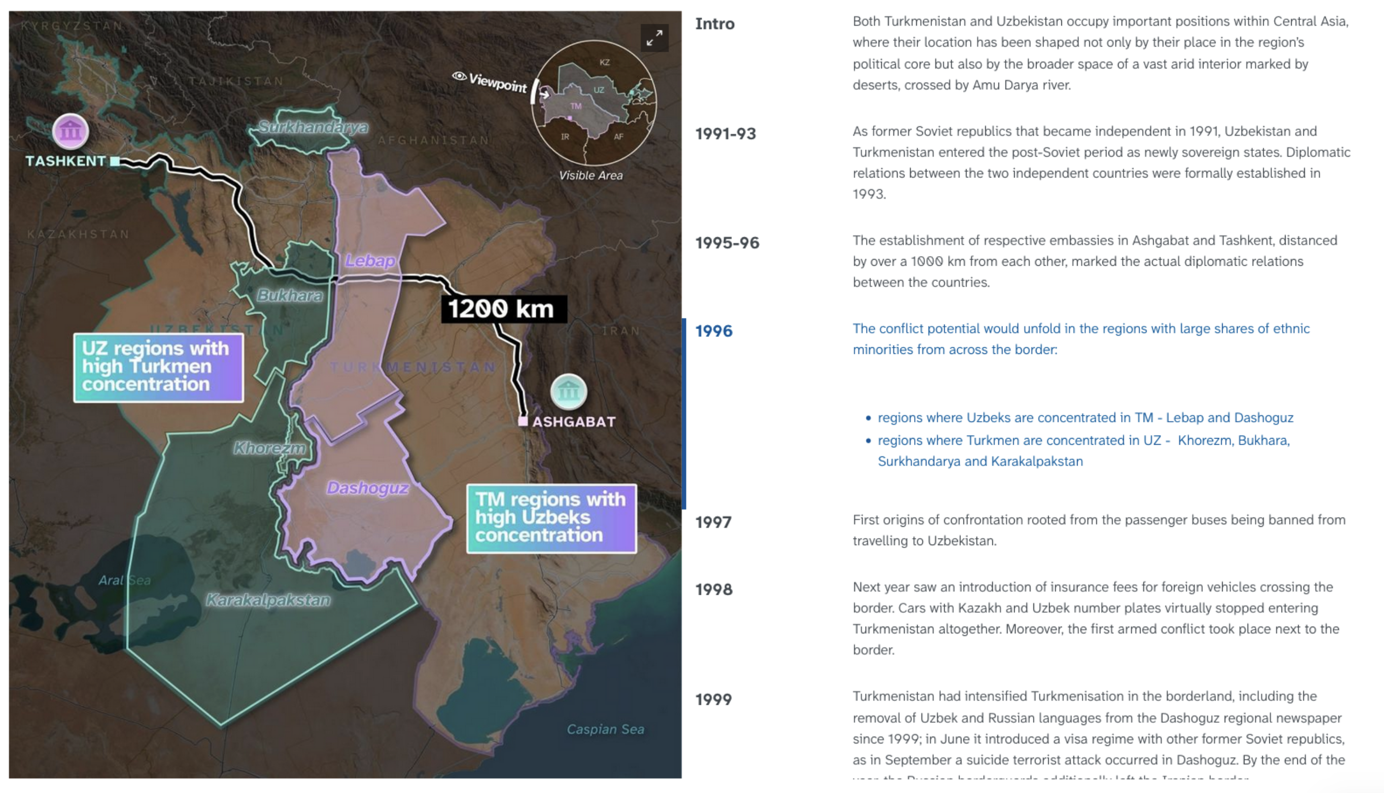
Ekaterina: As a scholar working on Central Asian topics but not hailing from the region, I was cautious not to overstep my role while making a visualisation. For this reason, I opposed Iaroslav’s suggestion to turn the map, so the state border of Turkmenistan and Uzbekistan appears as a vertical line separating (and connecting) the two countries, with Uzbekistan on the left and Turkmenistan on the right. In my view, this solution, while creative, was not something I am comfortable with. Turning a map felt like an unintended act of imposing epistemological hegemony on the region by outsiders. As a result, we kept the conventional map orientation.
Iaroslav: In order to avoid creating an excessive number of separate map frames, the events and processes represented on the map were organized into groups that would progressively populate the visualization. This approach reduced the number of individual map canvases required and ultimately made it possible to incorporate the timeline directly alongside the map, making the temporal progression considerably easier to follow. Here, the Visualisation Lab mobilised its experience of making timeline modules gained during the visualisation of the Abkhazia case (https://visualisingconflictpeace.de/cases/infrastructure-linkages-in-patron-client-relations ).
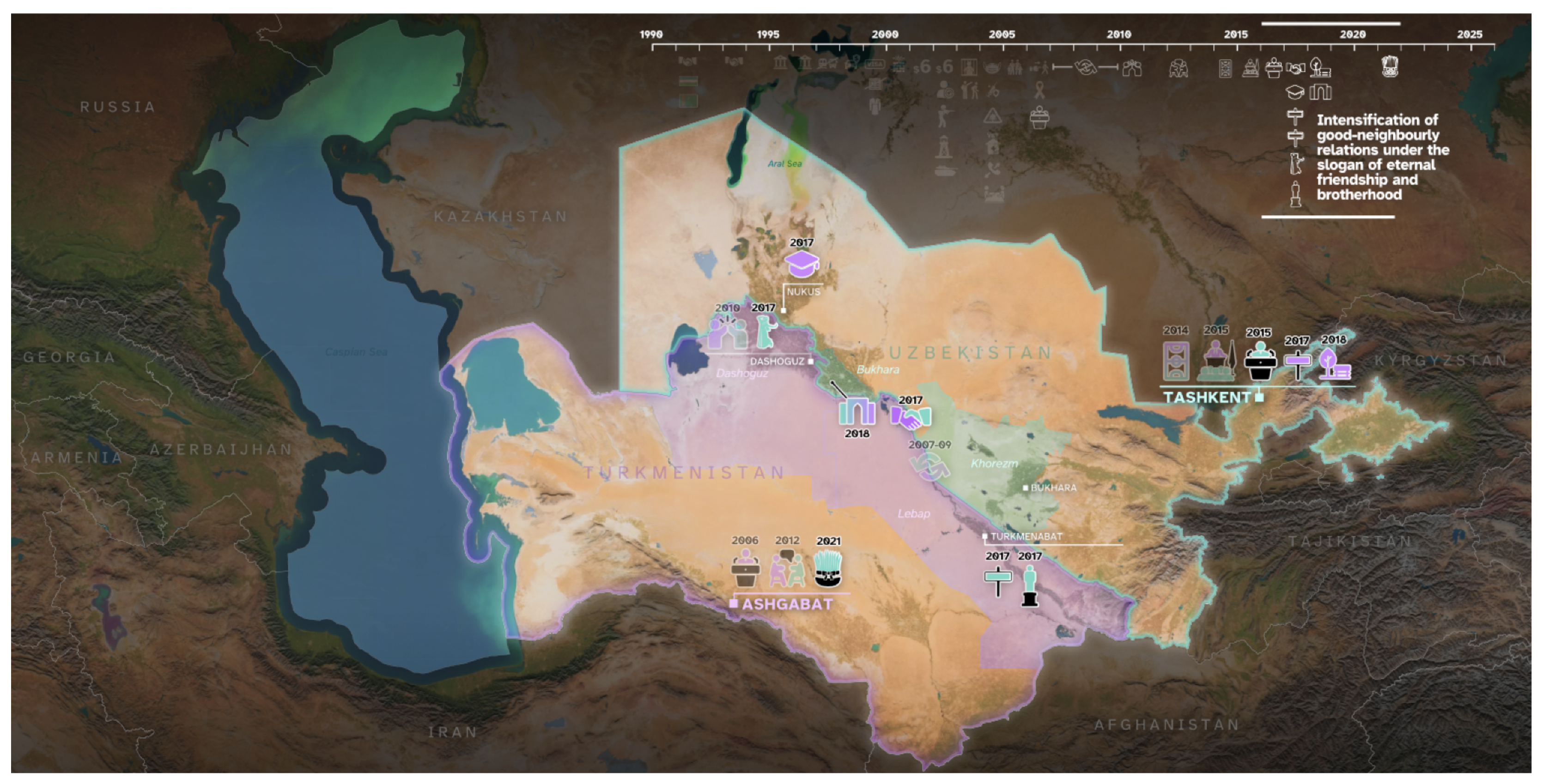
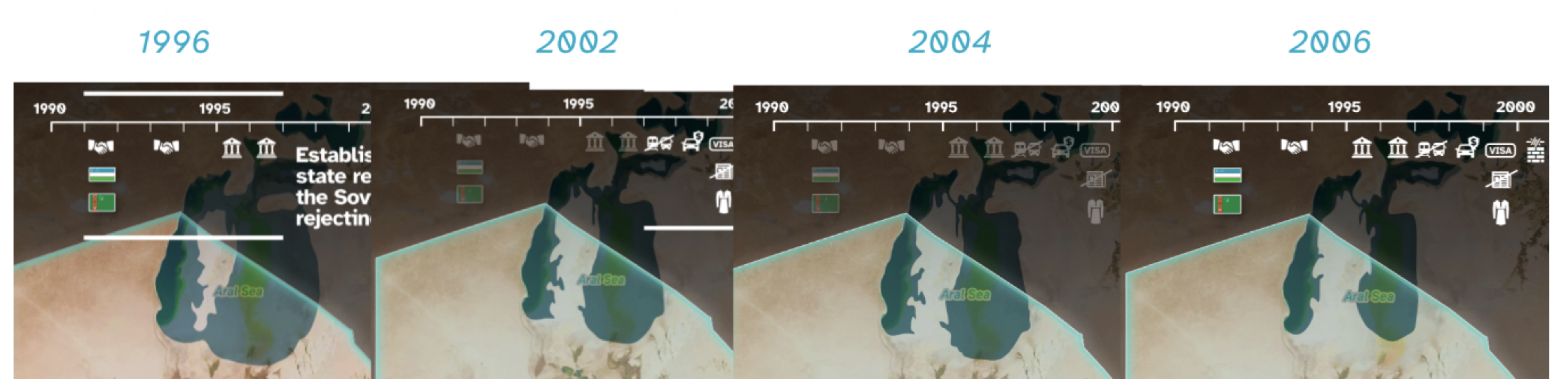
Ekaterina: It quickly became evident that visualizing changes in bilateral and cross-border realities on a static map is misleading. Central Asia is one of the regions undergoing rapid and dramatic landscape transformations, making static maps inadequate. This is particularly evident in the ongoing desiccation of the Aral Sea. I experienced this firsthand during my visit to Moynaq in Karakalpakstan, a former fishing village once located on the sea shore, now over 150 km from the Aral Sea. I emphasized that without depicting the Aral Sea's shrinkage, our visualization would be inaccurate.
Iaroslav: To maintain accuracy, I redrew the historical outlines of the Aral Sea for different years, showing how its extent progressively diminished over time. In addition to the political, social, and cross-border processes represented on the map, this element introduces an important environmental dimension and makes the changing ecological context visible throughout the timeline.
Ekaterina: The scarcity and incompleteness of data meant that precise geolocating of facts was often far from straightforward. For example, the scope and details regarding repression in the borderland often was unknown – e.g., where exactly ethnic Uzbek families were evicted to in Turkmenistan in 2004-2005 remains unknown. The reported facts are shown on the map with a degree of detail available - on the respective side of the border or in a particular region.
One such imprecision is worth a special mention: the visualisation of changes of the boundary between Turkmenistan and Uzbekistan. We know that the boundary was “adjusted” in the Shumanay district in 2005, yet the information on how exactly the borderline changed remains obscure.
Iaroslav: Uncertain location was not uncommon for events we visualised. For example, the spatial extent of the plague outbreak in 2004 remains unknown to us. In addition, the locations of certain formal or institutional events were not always evident. In such cases, it was necessary to assume a certain approximate or more abstract spatial relationship and position the events on the map accordingly. Therefore, the data has a somewhat fragmented spatial context. While many events can be linked to specific points, cities, or locations, others can only be represented through approximate or interpretative spatial references.
Ekaterina: Yet, positioning the events on the map was only half of a challenge. Another challenge came from choosing suitable icons.
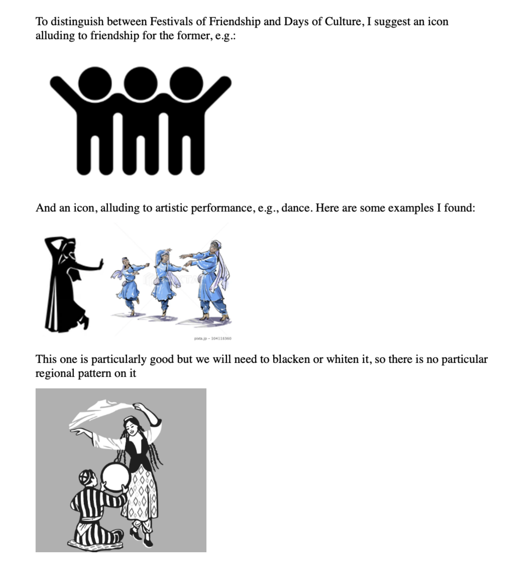
Iaroslav: The main icon source for the map comes from various contributors at flaticon.com. Several icons were generated and refined via AI (ChatGPT). Many of the events were difficult to visualize because of their specific cultural and social contexts. This became a distinct and particularly complex part of the design process, as it was difficult to develop a visual language that would represent all of these events appropriately and consistently. For instance, it was not immediately obvious how to represent cultural days taking place in different cities on the map, or how to visually communicate events such as an assassination attempt or an embassy storm. After sharing the first draft, I received more specific guidance from Ekaterina regarding how particular events should be represented or illustrated on the map.
Mela: We initially suggested to conclude the visualisation with a slider which would allow the reader to “slide” between the conflict and cooperation maps. This would allow a comparison of the maps and their juxtaposition. But Ekaterina, you pointed to critical issues with such a way of seeing in regards to the temporal perspective?
Ekaterina: While the visualisations produced for the Atlas are meant to be read side by side, it was clear to me that the usual juxtaposing tool with two images overlayed on top of each other would not work. Each visualisation presents a set of consecutive events: the first one shows the crisis dynamic which culminated in 2002 when the two states nearly came to war with each other, and the second one presents increasing collaborative activities from mid-2000s to mid-2020s. Conflating over the thirty years of interactions into a static image showing all icons from all the years of conflict and collaboration at the same time will be a misrepresentation rather than a summary, confusing rather than revealing, as both conflict and collaboration were diffused in time.
Mela: For these reasons, we decided to maintain a timeline view with several maps showing key periods of time which Ekaterina delineated. We discussed the possibility of visualising conflict and cooperation events next to each other on these period maps. However, this idea was dismissed in order to keep the focus on how the conflict was made invisible in the period of cooperation and coming together. As the conflict events were pushed under the carpet, making them visible within a cooperation map would be misguiding. The juxtaposition view would make sense in future potential visualisations if we would like to zoom into specific spatialisation patterns within the mapped events or if we wanted to zoom into specific areas of the maps for a more detailed view of how they were affected by both sets of events. Still, the uncertainty and lack of data currently makes such research difficult to undertake.